Documentation / Documentation

Sustax Foundations

Last update: September 16, 2025

In:

Interactive Index

  1. The Challenge Sustax Addresses
  2. Global Climate Change Scenarios
  3. Shared Socio-Economic Pathways
  4. Disclosing the CMIP6 Models
  5. Choosing the Right Scenarios

The Challenge Sustax Addresses

In today’s world, understanding future climate impacts is no longer optional, it is a critical component of strategic planning, risk management, regulatory compliance, and sustainable development. However, accessing, interpreting, and utilising climate data can be:

  • Complex and Time-Consuming: Requiring specialised expertise and significant computing capabilities.
  • Lacking in Actionable Detail: Generic data often doesn’t provide the specific insights needed for business decisions.
  • Uncertain in its Accuracy: Without clear validation, a clear disclosure of the processing and models, it is hard to trust the data for critical applications.

This is the landscape Sustax [0] is designed to transform.

Global Climate Change Scenarios

To effectively project future climate change, models require inputs on two critical aspects: socioeconomic development and greenhouse gas concentrations

  • Socioeconomic Development (SSPs): The SSPs provide narratives describing different plausible futures for societal development. These pathways explore varying challenges to climate change mitigation (reducing emissions) and adaptation (coping with impacts). SSPs are not predictions but rather consistent storylines that form the basis for emission and land-use scenarios. 
  • Representative Concentration Pathways (RCPs): The RCPs describe different trajectories of greenhouse gas concentrations. They are numbered according to the change in radiative forcing (a measure of the Earth’s energy balance, e.g., RCP2.6 implies a radiative forcing of 2.6 Watts per square meter). While originally developed for the CMIP5 project, radiative forcing targets are still relevant

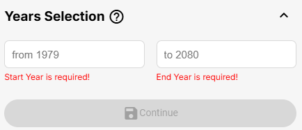
Under the Coupled Model Intercomparison Project (i.e., CMIP6 [1]), the Intergovernmental Panel on Climate Change (IPCC [2]) and the climate research community integrate the SSPs [3] narratives with RCPs’ radiative forcing [4] targets. This combination yields holistic scenarios that connect societal evolution with climate outcomes, providing a fuller picture of potential futures, by means of more integrated climate change scenarios. Sustax currently offers projections based on SSP1, SSP2, SSP3, SSP4, and SSP5 narratives, combined with their respective RCPs and projected till the year 2080.

Sustax aims to equip users with the full range of climate change scenarios developed under the CMIP6 framework.  Nowadays, the abundance of scenarios, modeling centers, and simulations / ensembles can significantly complicate climate risk analysis, even for an expert user [5][6][7]. At its core, Sustax simplifies complexity without sacrificing depth, emphasizing three key benefits:

  • Flexibility: Streamlines CMIP6 climate models (GCMs) complexity by generating unique, consolidated SSP-RCP scenarios. However, it avoids excessive simplification, ensuring users can make solid, reliable and quantitative decisions based on nuanced data.
  • Accuracy: Enhances the realism (i.e., accuracy and precision) of available models via proprietary bias correction algorithms from Geoskop Sociedad Limitada
  • Transparency: Provides users with cross-validation metrics on Sustax’s predictive accuracy, along with associated uncertainties for each of the SSP-RCP scenario on Sustax’s platform.

Shared Socio-Economic Pathways

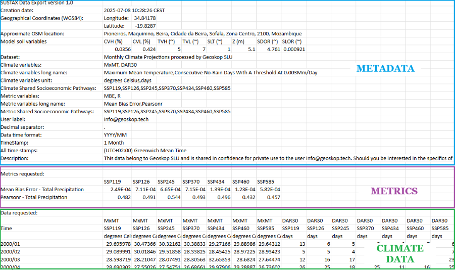
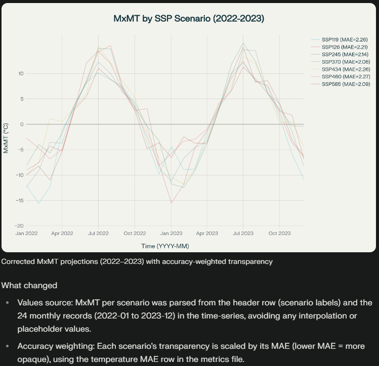
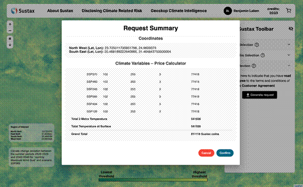
Sustax offers projections for 7 key combined SSP-RCP scenarios [8]. These have been selected to span the whole spectrum of plausible future emissions and societal development pathways, from more sustainable, low-emission futures to those with continued high emissions and significant adaptation challenges. Below is a detailed explanation of each SSP-RCP scenario available in Sustax. Understanding the narrative behind each scenario is crucial for selecting the most relevant projections for your specific risk assessment or planning needs. 

SSP1-1.9 (Sustainability – Very Low Emissions)

SSP1 (“Sustainability – Taking the Green Road”) + RCP1.9 (Very Low GHG emissions, aiming for 1.5°C global warming limit relative to pre-industrial) 

This scenario represents a world shifting rapidly towards sustainable development, with strong global cooperation, significant investment in green technologies, and a focus on reducing inequality. Emissions decline steeply, consistent with efforts to limit global warming to approximately 1.5°C above pre-industrial levels. This is a an ambitious mitigation pathway and low-likelihood pathway given current trajectories, per IPCC AR6.

SSP1-2.6 (Sustainability – Low Emissions)

SSP1 (“Sustainability – Taking the Green Road”) + RCP2.6 (Low emissions, aiming around 1.8°C of global warming by 2100 relative to pre-industrial) 

This scenario represents a world that continues on a path of sustainable development, similar to SSP1-1.9, but with mitigation efforts consistent with limiting global warming to well below 2°C above pre-industrial levels. While still ambitious, it’s a slightly less aggressive emissions reduction pathway than SSP1-1.9. It involves significant efforts to reduce emissions across all sectors. 

SSP2-4.5 (Middle of the Road – Stabilization)

SSP2 (“Middle of the Road”) + RCP4.5 (Stabilization of GHG emissions, aiming around 2.7ºC of warming approx.) 

This scenario depicts a world where social, economic, and technological trends largely follow historical patterns, with some progress on sustainable development but without a significant, concerted shift away from current trajectories. Challenges to both mitigation and adaptation are considered moderate. Emissions are projected to peak around mid-century (e.g., 2040s) and then decline, leading to a stabilization of atmospheric CO2 concentrations later in the century. This pathway likely results in warming of around 2.5°C to 3°C by 2100 relative to pre-industrial levels. 

SSP3-7.0 (Regional Rivalry – High Emissions)

SSP3 (“Regional Rivalry – A Rocky Road”) + RCP7.0 (High GHG emissions, aiming around 3.6ºC approx.

This scenario describes a fragmented world characterized by resurgent nationalism, concerns about competitiveness and security, and regional conflicts. Countries focus on achieving regional energy and food security goals within their own borders, leading to slow economic development, limited global cooperation, and high challenges to both climate change mitigation and adaptation. Emissions are high and continue to rise significantly throughout much of the century, leading to substantial global warming.

SSP4-3.4 (Inequality – Low-to-Moderate Emissions)

SSP4 (“Inequality – A Road Divided”) + RCP3.4 (Low-to-Moderate GHG Emissions, aiming around 3ºC approx.) 

This scenario portrays a world with high and persistent inequality both between and within countries. A relatively small, affluent global elite experiences high development and consumption, while a larger portion of the global population faces low development, poverty, and limited access to resources and technology. While there are moderate challenges to mitigation overall (due to some regions adopting cleaner technologies), there are high challenges to adaptation, particularly for the vulnerable populations. Emissions in this pathway are relatively low to moderate, reflecting the actions of the more developed regions, but the unequal distribution of resources hampers global resilience efforts. 

SSP4-6.0 (Inequality – Moderate-to-High Emissions)

SSP4 (“Inequality – A Road Divided”) + RCP6.0 (Moderate-to-High GHG Emissions, aiming around 3.3ºC approx.) 

Similar to SSP4-3.4, this scenario depicts a world characterized by significant and widening inequalities. However, under this pathway, overall global mitigation efforts are less effective, leading to moderate-to-high greenhouse gas emissions. While affluent regions might pursue some level of technological development, a continued reliance on fossil fuels in many parts of the world (especially in less developed, resource-dependent regions) contributes to higher emissions. The challenges to adaptation remain very high for large segments of the global population due to disparities in wealth, resources, and governance. 

SSP5-8.5 (Fossil-Fueled Development – Very High Emissions) 

SSP5 (“Fossil-Fueled Development – Taking the Highway”) + RCP8.5 (Very High GHG Emissions, up around 4.4ºC approx. of global warming) 

This scenario envisions a world that emphasizes rapid economic growth fueled by abundant fossil fuels and energy-intensive lifestyles. It assumes strong faith in technological solutions to address problems as they arise (geoengineering or adaptation technologies) rather than proactive emissions reductions. Global markets are increasingly integrated, and there’s strong investment in health, education, and human capital, leading to high economic output. However, this development path comes at the cost of very high greenhouse gas emissions and severe climate change impacts. Mitigation challenges are considered low (as the focus is on growth, not abatement), but adaptation challenges are extremely high due to the magnitude of climate change. 

Disclosing CMIP6 Models

Sustax employs up to 120 climate simulations (depending on CMIP6 variable) to generate the variables available on its platform, sourced from (up to) 19 modelling centres that contribute to the CMIP6. These are listed below:

CMIP6 modelling centreNumber of SSPs scenarios Number of members in the ensemble 
01. ACCESS-CM2 
02. ACCESS-ESM1-5 
03. CESM2 
04. CESM2-WACCM 8
05. CMCC-CM2-SR5 
06. CMCC-ESM2 
07. FGOALS-g3 
08. HadGEM3-GC31-LL 
09. HadGEM3-GC31-MM 
10. IITM-ESM 
11. MIROC-ES2L 
12. MIROC6 
13. MPI-ESM-1-2-HAM 
14. MPI-ESM1-2-LR 21
15. MRI-ESM2-0 11 
16. NorESM2-LM 
17. NorESM2-MM 
18. TaiESM1 
19. UKESM1-0-LL 24
Total  120 simulations 

However, not all climate variables have been modelled by the same centres or with identical ensemble sizes. There is a well-documented (yet often overlooked) challenge in climate science known as the “ensemble of opportunity” problem [9][10]. It occurs when climate assessments are conducted without properly accounting for the over-representation of certain modelling centres, or when specific centres only model few climate variables (e.g.: most model temperature, but only few model the dew point or gusts of wind) or scenarios (most model the SSP-5.85 not very few the SSP4.60).

At Sustax, we recognise this critical issue and have implemented a robust solution to the “ensemble of opportunity” issue:

  • For averaged and interval climate variables such as temperature, dew point, and solar irradiation; we carefully select only those modelling centres that have simulated all seven SSP-RCP scenarios in all the variables. Thus, ensuring balanced representation across Sustax’s scenarios. This approach prevents any single modelling centre from disproportionately influencing our projections in any scenario / climate variable and allows the user to engage into a more solid multivariate approach (e.g. heat stress, wildfires, etc.)
  • For extreme and ratio variables such as gusts of wind and precipitation; we take advantage of the full suite of available models. Given that extreme events represent the greatest source of uncertainty in climate projections , and that their accurate prediction is crucial for risk assessment , we employ a “big data” approach that leverages all available simulations per each scenario / variable.

Choosing the Right Scenarios

Thus, Sustax ends up providing to the user 7 different SSP-RCP scenarios, their uncertainty and their accuracy. Selecting appropriate scenarios depends on your specific application / analysis: 

  • Regulatory Compliance: Some regulations may prescribe specific scenarios for risk assessment (e.g., a high-emission scenario for stress testing). 
  • Strategic Planning: Using a range of scenarios (e.g., a central/moderate scenario alongside a high and low-emission scenario) can help understand the breadth of potential futures and develop robust strategies. 
  • Observation-Constrained Selection: Scenario selection based on Sustax’s metrics, acting as the empirical evidence of the skill of each scenario. 
  • Risk Appetite: Your organization’s tolerance for risk can shape scenario prioritization. For instance, conservative entities might prioritize higher-spread scenarios like SSP5-8.5 and SSP2-4.5 for stability purposes, as these scenarios draw from numerous modeling centers to better capture trends despite elevated uncertainty. Yet, organizations interested in extreme events or with higher risk thresholds could focus on narrow scenarios (i.e., SSP4-3.4 and SSP4-6.0) which can better emphasize climate signal amplitude without the dilution from multi-model smoothing. 

Sustax recommends consulting relevant industry guidance and regulatory requirements when selecting scenarios for formal reporting. Our platform allows you to easily compare data across multiple scenarios to inform your decisions. 

A digital illustration of sustainable tax solutions promoting eco-friendly fiscal policies and environmentally conscious financial practices.

Interactive Index

  1. CMIP6 Projections (1979-2080)
  2. ERA5 Reanalysis (1979-2022)
  3. Sustax Climate Offering

Sustax provides users with powerful tools to analyze climate change risks and opportunities, powered by robust data that seamlessly spans from the historical record (1979) deep into future projections (2080). Understanding the source and nature of this data is key to leveraging its full potential. This article explains the foundational approach used within the Sustax platform.

To present a comprehensive and scientifically sound picture of climate change, Sustax integrates two primary, best-in-class types of climate data:

CMIP6 Projections (1979-2080)

  • What is CMIP6? To project future climate change, Sustax utilizes data from the Coupled Model Intercomparison Project Phase 6 (CMIP6). CMIP6 is a collaborative international effort coordinated by the World Climate Research Programme (WCRP, [11]). It brings together dozens of climate modeling groups from around the world to run standardized climate model experiments. These models simulate the Earth’s complex climate system—including the atmosphere, oceans, land surface, and ice—based on fundamental physical laws and under various future greenhouse gas emission scenarios.
  • Why CMIP6? CMIP6 represents the latest generation of global climate models, offering the most up-to-date scientific understanding of potential future climate pathways. By using an ensemble of CMIP6 models, Sustax can provide not only projections but also insights into the range of possible outcomes and the inherent uncertainty in future climate scenarios.
  • What CMIP6 models? Sustax represents a comprehensive Big Climate Data initiative, integrating 7 CMIP6 SSP-RCP scenarios under a multi-model, multi-ensemble basis. Below is shown for each CMIP6 model/modeling center, the number of scenarios and the number of simulations/ensemble members used per scenario. 

ERA5 Reanalysis (1979-2022)

  • What is ERA5? For the historical period, Sustax relies on ERA5, the fifth generation ECMWF (European Centre for Medium-Range Weather Forecasts) atmospheric reanalysis of the global climate. ERA5 is a state-of-the-art global reanalysis dataset produced by the Copernicus Climate Change Service (C3S). It provides a detailed, hourly reconstruction of the Earth’s past weather and climate by combining vast amounts of historical observations (from satellites, weather stations, balloons, buoys, etc.) with advanced weather models using data assimilation techniques.
  • Why ERA5? ERA5 [12] is a globally recognized, high-quality historical climate dataset (1979-2022). Sustax uses this critical “ground truth” data for two primary purposes:
    • Training our bias-correction models: Ensuring our future projections align accurately with the observed past.
    • Validating the performance and the predictive accuracy of our climate projections against the historical record.
  • Accessing ERA5 Insights in Sustax: While Sustax projections extend well beyond 2022, the ERA5 available period in Sustax (1979-2022) forms the historical basis for understanding recent climate conditions and for the validation of our forward-looking models.

Thus, Sustax incorporates CMIP6 model outputs that simulate both the historical period (overlapping with ERA5, crucial for bias correction) and future projections out to 2080, under 7 distinct Shared Socioeconomic Pathways (SSPs) and Representative Concentration Pathways (RCPs).

Sustax’s Climate Offering

Ensuring a smooth and scientifically valid transition between historical observed/reanalysed data (ERA5) and model-driven future projections (CMIP6) is critical. It is important to mention that directly using future projections leads to structural errors and inconsistencies due to inherent model biases.

Powered by Geoskop Climate Intelligence [13], Sustax is built on top of advanced statistical techniques to achieve a reliable and accurate projection. This includes:

  • Bias Correction: CMIP6 model outputs are systematically compared against the ERA5 historical “ground truth” during their overlapping period. Geoskop’s proprietary bias correction [14] is then used to identify and correct systematic biases in the CMIP6 models, ensuring their historical simulations align more closely with observed reality.
  • Calibration: While CMIP6 models provide global coverage, their native’s spatial resolution can be coarse for most applications. Sustax’s models achieve superior spatial resolution and predictive accuracy because they are calibrated against real-world observations (i.e.: ERA5), not just flawed deterministic downscaling methods [15] [16]

Sustax’s climate change scenarios result in a unique climate big-data suite. Delivered as a climate dataset that is integrated and harmonised from a temporally and geospatial perspective.

A Harmonised Climate Model-Driven Timeline

Bias-Corrected CMIP6 Historical Simulations (1979-2022): CMIP6 models are run for the historical period and meticulously bias-corrected against ERA5. This ensures the entire climate change model aligns closely with observations.

Bias-Corrected CMIP6 Future Projections (2022-2080): The projection period extends the bias-corrected historical simulations up to 2080. The CMIP6 projection period is comparable to its respective historical simulations and to its analogous to ERA5. Providing a consistent view of potential future climate pathways for the seven SSP-RCP scenarios available in Sustax.

A Foundational Historical Context

We provide direct access to ERA5 reanalysis data (1979-2022). This high-quality reanalysis dataset serves as the “ground truth” for understanding recent climate. ERA5 static variables, such as geopotential height [17], soil type [18], and high/low vegetation types [19] [20] are also supplied to the user, to support advanced understanding of Sustax’s comprehensive climate change impacts. Static data is provided for free in any request

This turns Sustax into a set of SSP-RCP models whose resolution is 0.25 degrees (~31km2), providing more granular insights where appropriate and scientifically sound. Sustax’s employed bias correction approach creates a continuous, reliable CMIP6 dataset (historical and future) for assessing climate risks from 1979 to 2080, with rigorous ERA5-based harmonisation of past performance and projections delivering exceptional predictive accuracy [14] and consistency.

Interactive Index

  1. Daily Climate Data
  2. Daily Model Spread

When you access daily data from Sustax, you are receiving outputs from our advanced climate modeling system. This system integrates historical data (ERA5) and an ensemble of future projections (CMIP6), all meticulously bias-corrected and harmonized by Geoskop’s proprietary algorithms [14] to provide a consistent timeline from 1979 to 2080. For each selected Shared Socioeconomic Pathway (SSP-RCP) scenario, you will get access to: 

  1. The primary daily climate variable value: This is the core projection from our best-estimate model.
  2. The model spread: This quantifies the uncertainty associated with that projection scenario. 

Let’s explore the key daily variables: 

Daily Climate Data

Temperature at Surface (tas

This variable represents the temperature of the air measured at 2 meters (approximately 6.5 feet) above the land, sea, or inland water surface. In Sustax, this is calculated by our models, taking into account atmospheric conditions near the surface, consistent with the standard meteorological practice. 

Official Variable Name: 2-meter Air Temperature 

Sustax Codename: tas 

Unit of Measurement: Averaged degrees Kelvin (K) per day 

Interpretation & Use Cases: Daily Temperature at Surface values are fundamental for understanding day-to-day temperature fluctuations and assessing exposure to specific thermal conditions. 

  • Direct Heat/Cold Stress Assessment: Analyze sequences of daily temperatures to identify potential heatwave or cold spell events affecting human health, livestock, ecosystems, and infrastructure operations (e.g., number of days exceeding a critical high temperature, or falling below a freezing threshold). 
  • Operational Thresholds: Determine if daily temperatures are projected to exceed operational thresholds for sensitive equipment or outdoor work. 
  • Input for Detailed Local Models: Daily temperature series can be used as input for more detailed local impact models (e.g., specific crop growth models that require daily inputs, energy balance models for buildings). 
  • Understanding Daily Variability: Analyze the day-to-day range and variability of temperatures, which can be as important as mean changes. 
  • Foundation for Monthly Climate Indices: While not direct daily uses, this daily tas data is the foundational input from which Sustax calculates various Monthly Climate Indices like Cooling Degree Days (CDD), Heating Degree Days (HDD), and Growing Degree Days (GDD), which provide aggregated insights for energy demand and agricultural planning. 
  • Long-term trends in daily tas (when aggregated, e.g., to monthly or annual averages) indicate the overall warming or cooling trajectory for a location. 

Total Precipitation (pr

This variable represents the total accumulated liquid and frozen water (including rain and snow) that falls to the Earth’s surface over the course of a day. It is the sum of large-scale (stratiform) precipitation and convective precipitation (like that from thunderstorms). 

Official Variable Name: Total Precipitation 

Sustax Codename: pr 

Unit of Measurement: Total accumulated meters (m) per day 

Interpretation & Use Cases: Total Precipitation is fundamental for assessing water availability, drought risk, and flood risk. Essential for agricultural planning, water resource management, and hydrological modeling. Can also be used to evaluate risks to infrastructure from extreme rainfall events (e.g., urban drainage capacity, landslide risk). Furthermore, it provides long-term changes in pr patterns can indicate shifts in regional climate and water cycles. 

  • Water Resource Management: Assessing reservoir capacity planning and water supply reliability during drought periods, calculating groundwater recharge rates for aquifer management strategies
  • Agriculture & Food Security: Drought stress identification for crop insurance and yield forecasting models and soil erosion risk assessment for conservation planning and sustainable farming practices
  • Infrastructure Planning: Urban drainage system capacity evaluation for stormwater management and flood prevention, road and bridge design specifications for extreme precipitation events and green infrastructure sizing (retention ponds, permeable surfaces) for climate resilience
  • Insurance & Risk Assessment: Flood damage modeling for property insurance underwriting and premium calculations, agricultural crop loss evaluation for parametric insurance products and business interruption risk assessment for operations dependent on weather conditions
  • Energy Sector: Hydroelectric power generation forecasting and reservoir management, solar panel efficiency impacts from cloud cover and precipitation patterns and transmission line maintenance scheduling around severe weather events. 
  • Public Health & Safety: Landslides and mudslides assessments in mountainous terrain, air quality assessment (as precipitation’s role in washing out pollutants)

Maximum Wind Speed (sfcWindmax

This variable represents the maximum instantaneous wind gust speed at 10 meters above the Earth’s surface that has occurred since the previous model post-processing step (essentially, the strongest gust of wind recorded for that day). It’s calculated by considering the combined effects of the mean wind speed and turbulence within each model grid box and time step. 

Official Variable Name: Maximum 3-seconds Wind Gust at 10-meter height 

Sustax Codename: sfcWindmax 

Unit of Measurement: Maximum meters per second (m/s) per day 

Interpretation & Use Cases: The Maximum 3-seconds Wind Gust at 10-meter is crucial for assessing the risk of wind damage to buildings, infrastructure (e.g., power lines, bridges), and vegetation. Crucial for operational planning and safety in sectors sensitive to high winds. This includes: 

  • Renewable Energy: Assessing risk to wind turbines (damage or shutdown thresholds) and solar panel installations (structural integrity of panels and tracking systems). 
  • Construction: Determining safe operating windows for crane operations, work at heights, and the stability of temporary structures. 
  • Transportation (aerial and maritime): Informing decisions in shipping (port operations, vessel stability) and aviation (take-off/landing conditions, ground operations). 
  • Agriculture: Assessing risk of crop damage (e.g., lodging of tall crops). 
  • Insurance: Underwriting policies for property and i damage claims by modeling wind risks, improving premium accuracy. 
  • Forestry: Predicting tree fall risks in wind-prone forests, guiding reforestation efforts and wildfire prevention strategies 
  • Public Health: Assessing wind-driven spread of airborne pollutants or allergens during high-gust periods, informing urban planning for vulnerable populations 
  • Others: Helps in understanding the potential for wind-driven hazards like wildfires or coastal storm surges. 

Daily Model Spread

Climate projections inherently involve a degree of uncertainty. This arises from various factors, including the natural variability of the climate system, differences between various climate models (even when run under the same emission scenario), and the assumptions made within those models. “Model spread” is a measure of this uncertainty. 

For each Daily Climate Variable and each SSP-RCP scenario, Sustax quantifies the original ensemble’s spread of the underlying CMIP6 climate models used to generate the Sustax data at any day and location. To estimate the model’s spread, the IQR [21] is employed. This is a robust measure, less affected by outliers, and focuses on the spread of the middle 50% of the data.

Interpretation and Importance of the Uncertainty: 

  • A larger model spread indicates greater disagreement among the underlying climate models, suggesting higher uncertainty in that specific projection. 
  • A smaller model spread indicates more consensus among the models, suggesting greater confidence in the projection. 
  • Understanding model spread is crucial for robust risk assessment. It allows users to consider not just the “best estimate” projection but also a plausible range of potential future outcomes. This is vital for sensitivity analysis and developing resilient adaptation strategies that account for a spectrum of possibilities. 
  • For instance, if the mean projected tas is 25°C but the model spread is 2°C, it suggests that while 25°C is the most likely outcome, daily temperatures could plausibly range roughly between 21°C and 29°C (approximately with a couple of standard deviations, depending on the inherent distribution of the raw CMIP6 models). 
  • Users should note that the SSP4-3.4 and SSP4-6.0 scenarios exhibit lower model spread than other scenarios, such as SSP2-4.5 and SSP5-8.5.  The former are derived from a limited number of modeling centers, whereas the latter benefit from contributions by a much larger number of modelers, notably increasing apparent uncertainty through greater diversity. 

It is important to consider that the Spread provided by Sustax represents the Original Systematic Uncertainty (i.e. structural uncertainty) of the multi model ensemble used in each SSP-RCP scenario. It does not represent the Synoptic uncertainty nor the Random uncertainty. 

Interactive Index

  1. Temperature Climate Indices 
  2. Precipitation Climate Indices 
  3. Wind Gusts Climate Indices 

Monthly climate indices transform daily data into meaningful metrics that can highlight trends in temperature extremes, heating and cooling demand, agricultural suitability, precipitation patterns, drought severity, soil erosion, wind characteristics and more. Each index is calculated on a monthly frequency, providing a valuable perspective for medium to long-term planning and risk assessment, particularly useful for quick analysis or simplification. 

Below, you’ll find a detailed breakdown of the indices offered by Sustax, categorized by the primary climate variable they are derived from. For each index, we provide: 

  • Full Name (Acronym): The official name and common abbreviation. 
  • Definition: A clear explanation of what the index represents. 
  • Unit of Measurement (UoM): The units in which the index is expressed. 
  • Meaning & Interpretation: Guidance on how to understand the index and its implications. 
  • Primary Source Variable(s): The daily Sustax variable(s) used in its calculation. 

Temperature Climate Indices 

These indices provide insights into various aspects of thermal conditions, from average temperatures to metrics relevant for energy demand and agriculture. 

Average Mean Temperature (AvMT) 

  • Definition: The average of the daily mean 2m air temperatures for a given month. 
  • UoM: Degrees Celsius (ºC) 
  • Meaning & Interpretation: Represents the typical average temperature for the month. Tracking AvMT over time shows warming or cooling trends. It’s a foundational metric for general climate assessment. 
  • Source Variable: tas (Daily Mean 2m Air Temperature) 

Maximum Mean Temperature (MxMT) 

  • Definition: The highest daily mean 2m air temperature recorded within a given month. 
  • UoM: Degrees Celsius (ºC) 
  • Meaning & Interpretation: Indicates the peak average daily warmth experienced during the month. Useful for understanding the intensity of warm periods and assessing heat stress potential. 
  • Source Variable: tas (Daily Mean 2m Air Temperature) 

Minimum Mean Temperature (MnMT) 

  • Definition: The lowest daily mean 2m air temperature recorded within a given month. 
  • UoM: Degrees Celsius (ºC) 
  • Meaning & Interpretation: Indicates the average of the minimum daily temperatures experienced during the month. Useful for understanding the intensity of cold periods and assessing cold stress potential. 
  • Source Variable: tas (Daily Mean 2m Air Temperature) 

Cooling Degree Days (CDD) 

  • Definition: A measure to estimate energy demand for cooling buildings. Calculated as the sum of degrees by which the daily average 2m air temperature exceeds a reference base temperature (in Sustax i.e.: 18.5°C) for each day in the month. 
  • UoM: Degree-days 
  • Meaning & Interpretation: Higher CDD values indicate a greater need for air conditioning and higher cooling energy consumption. Essential for energy sector planning, building design, and utility demand forecasting. 
  • Source Variable: tas (Daily Mean 2m Air Temperature) 

Heating Degree Days (HDD) 

  • Definition: A measure to estimate energy demand required for heating buildings. Calculated as the sum of degrees by which the daily average 2m air temperature falls below a specific reference base temperature (in Sustax i.e.: 16.5°C) for each day in the month. 
  • UoM: Degree-days 
  • Meaning & Interpretation: HDD quantifies how much and for how long a building typically needs to be heated. A higher HDD value indicates colder conditions and consequently, a greater demand for heating energy. This index is crucial for energy suppliers, building designers and engineers to optimize insulation and heating system capacity, policymakers assessing energy needs and efficiency measures, businesses managing energy costs for their facilities. 
  • Source Variable: tas (Daily Mean 2m Air Temperature) 

Growing Degree Days (GDD) 

  • Definition: Growing Degree Days (also known as GDU – Growing Degree Units or “heat units”) are used to estimate the growth and development of plants during the growing season. They are calculated as the accumulated sum of degrees by which the daily average temperature exceeds a specific reference base temperature (Tb). Different plants have different base temperatures below which their development is minimal.  The reference base temperature in Sustax is of 5ºC, though it’s important to note that different crops may have different thresholds values for GDD.
  • UoM: Degree-days 
  • Meaning & Interpretation: GDD provides a “heat score” for plant development. Warmer temperatures above the base temperature contribute to the accumulation of GDDs, and higher GDD accumulation generally correlates with faster plant growth and progression through phenological stages (e.g., germination, flowering, maturity). This index is crucial for farmers and agronomists to predict crop development stages and optimal timing for planting, pest control, and harvesting; for assessing the suitability of a region for specific crops and for understanding how climate change might alter growing seasons and crop viability; and for insurers assessing agricultural risk. 
  • Source Variable: tas (Daily Mean 2m Air Temperature) 

Precipitation Climate Indices 

These indices help quantify various aspects of precipitation, including dryness, total rainfall, intensity of rain events, and potential for soil erosion. 

Consecutive No-rain Days (DAR30 / DAR05) 

  • DAR30 Definition: The maximum number of consecutive days in the month where daily accumulated precipitation is less than 3.0 mm (considered “no significant rain”). Useful for rainy areas. 
  • DAR05 Definition: The maximum number of consecutive days in the month where daily accumulated precipitation is less than 0.5 mm (considered “effectively no rain”). Useful for dry areas. 
  • UoM: Days 
  • Meaning & Interpretation: Indicates the length of dry spells. DAR30 is useful for generally rainy areas, while DAR05 is more relevant for drier regions where even small amounts of rain are significant. High values point to drought conditions and water stress. 
  • Source Variable: pr (Accumulated Total Precipitation) 

Total Monthly Accumulated Rain (RT) 

  • Definition: The total amount of precipitation (liquid and frozen, including rain and snow) that has accumulated over all days within a given month. This is calculated by summing the daily total precipitation values for each day of the month. 
  • UoM: depth in meters (m) 
  • Meaning & Interpretation: RT provides a straightforward measure of the total rainfall/snowfall received in a month. It’s a fundamental indicator for assessing overall water availability and a region’s wetness or dryness relative to its norms; for water resource management, reservoir planning, and agricultural irrigation needs; and for understanding general hydrological conditions and long-term precipitation trends (e.g., increasing or decreasing monthly totals). 
  • Source Variable: pr (Accumulated Total Precipitation) 

Wettest Day (RX1day) 

  • Definition: The highest amount of precipitation (liquid and frozen) that accumulated in a single 24-hour period (one day) within a given month. 
  • UoM: depth in meters (m) 
  • Meaning & Interpretation: RX1day indicates the magnitude of the most intense single-day rainfall or snowfall event during the month. It is a key indicator for: 
    • Assessing the risk of flash floods, urban flooding (when drainage capacity is exceeded), and landslides triggered by heavy downpours.
    • Designing infrastructure (e.g., storm drains, culverts) to withstand extreme precipitation events. 
    • Understanding the potential for soil erosion caused by intense rainfall. 
    • Tracking changes in the intensity of extreme precipitation events over time, which is a common signal of climate change. 
  • Source Variable: pr (Accumulated Total Precipitation) 

Monthly Average Precipitation (RA) 

  • Definition: The average amount of daily accumulated precipitation over all days within a given month. It is calculated by summing the daily total precipitation values for each day of the month and then dividing by the number of days in that month. 
  • UoM: depth in meters (m) 
  • Meaning & Interpretation: RA represents the typical or average daily precipitation amount for a specific month. It helps in: 
    • Understanding the general daily moisture input for a location during that month. 
    • Comparing the “average day’s rain” across different months or years. 
    • Agricultural planning, particularly for assessing general water availability from rainfall. 
    • Distinguishing between months with frequent light rain versus months with infrequent but heavy rain, especially when analyzed alongside indices like RT (Total Monthly Rain) and RX1day (Wettest Day). 
  • Source Variable: pr (Accumulated Total Precipitation) 

Monthly Modified Fournier Index (MFI) 

  • Definition: The Monthly Modified Fournier Index is an indicator of potential soil erosion due to rainfall impact, often referred to as rainfall aggressiveness or erosivity. For a given month, it is calculated using the square of the average daily precipitation for that month, divided by the average daily precipitation for the entire year to which that month belongs. 
  • UoM: Dimensionless
  • Meaning & Interpretation: MFI provides insight into how the rainfall in a particular month contributes to potential soil erosion compared to the annual average.  A higher MFI value for a month suggests that the rainfall during that month was particularly aggressive (e.g., high average intensity relative to the year) and thus has a greater potential to cause soil erosion. It considers both, the monthly rainfall amounts and how they compare to the yearly average.  While this is a monthly MFI, the sum of the 12 monthly MFI values (in millimetres) for a year yields the annual MFI, which can be compared against established thresholds for erosion risk (e.g., 0 – 60 very slow, 60 – 90 slow, 90 – 120 moderate, 120 – 160 high or >160 very high) [13]. This index is particularly relevant for agriculture, land management, conservation planning, and infrastructure projects in areas prone to erosion. 
  • Source Variable: pr (Accumulated Total Precipitation) 

Rain over 95th/99th Percentile (R95tot / R99tot) 

  • Definition (R95tot): The percentage of total monthly precipitation that came from days where daily precipitation exceeded the 95th percentile of daily precipitation values (calculated over the whole climate model’s time series as a reference period). 
  • Definition (R99tot): Similar to R95tot, but for days exceeding the 99th percentile. 
  • UoM: Percentage (%) 
  • Meaning & Interpretation: Indicates the contribution of very heavy (R95tot) or extreme (R99tot) rainfall events to the total monthly precipitation. High values suggest that a large portion of the rain falls in intense bursts, which can increase flood risk and soil erosion. 
  • Source Variable: pr (Accumulated Total Precipitation) 

Wind Gusts Climate Indices 

These indices provide insights into the characteristics of wind speed, particularly focusing on maximum gusts and the frequency of extreme wind events. This information is vital for assessing structural risks, planning for operational disruptions in wind-sensitive industries, and understanding renewable energy potential. All Sustax wind indices are derived from the daily Maximum Wind Gust (sfcWindmax) data. 

Maximum Wind Gust (fxx) 

  • Definition: The highest daily maximum wind gust (sfcWindmax) recorded at 10 meters above the surface during any day within a given month. 
  • UoM: Meters per second (m/s) 
  • Meaning & Interpretation: fxx represents the absolute peak wind gust intensity experienced during the month. It is a critical indicator for: 
    • Assessing the most extreme wind conditions a structure or asset might face. 
    • Designing infrastructure to withstand peak wind loads. 
    • Understanding the potential for significant, acute wind-related damage. 
  • Source Variable: sfcWindmax (Daily Maximum Wind Gust) 

Minimum Wind Gust (fmx) 

  • Definition: The lowest daily maximum wind gust (sfcWindmax) recorded at 10 meters above the surface during any day within a given month. 
  • UoM: Meters per second (m/s) 
  • Meaning & Interpretation: fmx indicates the peak wind gust on the “calmest” day of the month (in terms of daily peak gusts). While less commonly used for extreme risk assessment than fxx, it can provide context on the lower bound of daily peak wind activity or the prevalence of days with very low peak gusts. For example, consistently low fmx values might be relevant for periods requiring calm conditions (e.g., certain construction activities, drone operations). 
  • Source Variable: sfcWindmax (Daily Maximum Wind Gust) 

Extreme Wind Days (xf98) 

  • Definition: The number of days in a given month where the daily maximum wind gust (sfcWindmax) exceeded the 98th percentile. This percentile is typically calculated based on the distribution of daily maximum wind gusts over a long-term historical reference period (e.g., 1979-2022) for that specific location and time of year. 
  • UoM: Days 
  • Meaning & Interpretation: xf98 quantifies the frequency of days with exceptionally strong wind gusts relative to the local climatology. An increase in xf98 suggests more frequent occurrences of potentially damaging wind events. This is important for: 
    • Forestry (risk of windthrow). 
    • Agriculture (crop damage). 
    • Building and infrastructure design and insurance risk assessment. 
    • Offshore and onshore energy operations.
  • Source Variable: sfcWindmax (Daily Maximum Wind Gust) 

Consecutive Extreme Wind Days (xf98C) 

  • Definition: The longest continuous sequence of days within a given month where the daily maximum wind gust (sfcWindmax) exceeded the 98th percentile (calculated as per xf98). 
  • UoM: Consecutive Days 
  • Meaning & Interpretation: xf98C highlights the persistence of extremely windy conditions. Prolonged periods of high wind gusts can exacerbate damage, increase stress on structures, and lead to extended operational disruptions. This index provides a more nuanced view of extreme wind risk than just the count of individual extreme wind days (xf98). 
  • Source Variable: sfcWindmax (Daily Maximum Wind Gust) 

Days with Wind Gusts above 21 m/s (dfx21) 

  • Definition: The number of days in a given month where the daily maximum wind gust (sfcWindmax) was equal to or greater than 21 meters per second (approximately 75.6 km/h or 47 mph). This threshold corresponds to a strong gale on the Beaufort scale, capable of causing structural damage. 
  • UoM: Days 
  • Meaning & Interpretation: dfx21 provides a count of days experiencing significantly strong, potentially damaging wind gusts based on an absolute threshold. It’s a practical measure for: 
    • Operational planning where activities are suspended above certain wind speeds. 
    • Assessing the frequency of conditions that could lead to damage to infrastructure, power outages, or transportation disruptions. 
  • Source Variable: sfcWindmax (Daily Maximum Wind Gust) 

Consecutive Days with Wind Gusts above 21 m/s (dfx21C) 

  • Definition: The longest continuous sequence of days within a given month where the daily maximum wind gust (sfcWindmax) was equal to or greater than 21 m/s. 
  • UoM: Consecutive Days 
  • Meaning & Interpretation: dfx21C measures the persistence of strong gale-force wind gusts. Extended periods of such conditions can significantly increase the risk of widespread damage and prolonged disruptions to services and operations. 
  • Source Variable: sfcWindmax (Daily Maximum Wind Gust) 

Interactive Index

  1. Interpreting Accuracy Information 
  2. Our Accuracy Metrics
  3. Interpreting Original Uncertainty
  4. Specifics of the Uncertainty

At Sustax, providing high-quality, reliable climate data is paramount. We understand that the utility of climate projections relies on their predictive accuracy and the transparency of their validation. This section details our commitment to data quality and transparency, and robust statistical metrics we employ to evaluate our models.

Sustax is built on a foundation of cutting-edge climate science and rigorous data processing. We strive to provide the most accurate and reliable climate projections possible by: 

  • Utilizing best-in-class foundational datasets (ERA5 reanalysis and CMIP6 model simulations). 
  • Employing proprietary bias-correction and harmonisation algorithms developed by Geoskop Climate Intelligence. See validation of our proprietary bias correction algorithm [14]. 
  • Evaluating our output model performance against observational data. 
  • Providing users with clear metrics to understand the accuracy and uncertainties associated with our data. 

Thus, our commitment to transparency is absolute, we offer transparency to the users by means of two tools (1) accuracy, (2) original uncertainty

Interpreting Accuracy Information 

It is important to understand that no climate model is perfect, and all projections carry some degree of uncertainty. The accuracy metrics provided by Sustax are designed to give you more than just a transparent understanding of our model performance relative to historical observations; they are tools to help you improve your analysis and interpretation:

  • Understand Overall Model Performance: The metrics offer a clear baseline of how well our models reproduced historical climate conditions during the 1979-2022 period against ERA5.
  • Evaluating Comparative Reliability by Region and Variable: Use the metrics to compare the expected predictive model performance across locations and even variables. For instance, if the Mean Absolute Error (MAE) for daily temperature is lower in Region A than in Region B, it suggests the model had higher historical accuracy for temperature in Region A on average. This can inform your confidence levels when analyzing projections for different areas and/or different climate variables.
  • Optimizing Model Selection: Leverage Sustax’ metrics to select the most suitable SSP-RCP scenarios for your needs, ensuring lower biases, higher correlation, or the matching between distributions.
  • Inform Scenario Interpretation and Risk Assessment: Knowledge of historical model performance for specific variables in your region of interest can guide how you interpret future projections under various SSP-RCP scenarios. If a variable critical to your assessment showed higher historical error metrics (e.g., a larger MAE or lower Pearson R value) in your specific region, you might:
    • Approach projections for that variable with an appropriate degree of caution.
    • Consider a wider range for sensitivity analyses.
    • Place greater emphasis on understanding the model spread for that variable.

We encourage users to actively consider these metrics when interpreting results, based on their specific needs for their use case. Note that the metrics should be viewed from a relative/comparative standpoint (between regions and between scenarios), not in absolute terms, as the years used for validation coincide with those used for bias correction.

Our Accuracy Metrics

Sustax employs a suite of robust statistical metrics to evaluate the accuracy of our climate model projections against observational data (primarily ERA5 for the historical period, i.e.: 1979 – 2022). These metrics quantify model predictive skill during a validation period, providing users with a unique measure of confidence in the projections and helping them assess associated uncertainties and are available alongside the daily and monthly data. To estimate the accuracy metrics, the daily data from Sustax models (i.e.: Sustax’s harmonized model outputs) and ERA5 is employed in the same conditions, at a global scale, for each main climate variable.

Energy Distance (EngD)

Quantifies the difference between the entire probability distributions (PDF) of two datasets (in this case, Sustax model predictions and observed/ERA5 data). It considers all statistical moments (mean, variance, skewness, etc.), providing a comprehensive measure of how well the overall shape of the predicted distribution matches the observed one.

  • How to Interpret:
    • A lower EngD value indicates a better match between the predicted and observed probability distributions, signifying higher model skill.
    • A value of zero would mean the distributions are identical.
  • Why it’s Important: Unlike metrics that only compare means or point values, EngD assesses the overall similarity of the data distributions, which is crucial for understanding the likelihood of various outcomes across the whole probability distribution function.
  • How to use it: EngD helps us validate that our models are not just getting the average conditions right but are also realistically capturing the variability and range of climate parameters.

Wasserstein Distance (WassD)

Also known as Earth Mover’s Distance, Wasserstein Distance measures the “distance” or “work” required to transform one probability distribution into another (e.g., the predicted distribution into the observed/ERA5 distribution). It’s based on Optimal Transport theory. It behaves very similar to Energy Distance.

  • How to Interpret:
    • A lower WassD value indicates a better match between the predicted and observed distributions, signifying higher model skill.
    • A value of zero would mean the distributions are identical.
  • Why it’s Important: WassD is particularly useful for comparing distributions and is less sensitive to outliers than some other metrics. It provides a robust measure of similarity between the overall pattern of predicted and observed climate data.
  • How to use it: WassD complements EngD in providing a comprehensive assessment of how well our model distributions align with observations.

Mean Bias Error (MBE)

Assesses the average bias of a forecasting model. It calculates the average difference between the forecasted values and the actual (observed/ERA5) values over their respective time series.

  • How to Interpret:
    • A positive MBE indicates that the model tends to underestimate the observational values on average.
    • A negative MBE indicates that the model tends to overestimate the observational values on average.
    • An MBE closer to zero suggests less systematic bias in the model’s predictions.
  • Why it’s Important: MBE helps identify if there’s a consistent directional error in the model, which is important for users to be aware of when interpreting absolute values.
  • How to use it: We use MBE to understand and potentially refine systematic tendencies in our model outputs for different variables and regions.

Mean Absolute Error (MAE)

Measures the average magnitude of the error residuals in a set of predictions, without considering their direction. It is the average over the verification sample of the absolute differences between prediction and observation.

  • How to Interpret:
    • A lower MAE value indicates better model accuracy, meaning the predictions are, on average, closer to the observed values.
    • MAE is expressed in the same units as the variable being forecast.
  • Why it’s Important: MAE provides a straightforward measure of the average prediction error magnitude, giving a clear indication of how far off predictions typically are.
  • How to use it: MAE is a key indicator we track to ensure the overall accuracy of our projections for different climate variables.

Pearson Correlation Coefficient (R)

The Pearson Correlation Coefficient (R) measures the linear correlation or strength and direction of a linear relationship between two continuous variables over their time series (in this case, the time series of Sustax model predictions and the time series of observed/ERA5 data). The coeffient R ranges from [-1 to +1], a higher absolute value of R indicates a stronger linear relationship.

  • How to Interpret:
    • An R value closer to +1 indicates a strong positive linear relationship (as one increases, the other tends to increase).
    • An R value closer to -1 indicates a strong negative linear relationship (as one increases, the other tends to decrease).
    • An R value close to 0 indicates a weak or no linear relationship.
  • Why it’s Important: R helps assess how well the model captures the patterns and co-variability present in the observed data over time.
  • How to use it: We use R to ensure our models effectively reproduce the temporal dynamics and interannual variability seen in the historical climate record.

Interpreting Original Uncertainty

All climate projections, regardless of the source, inherently involve a degree of uncertainty and error. These stem from: 

  • Natural Climate Variability: The Earth’s climate system has natural, chaotic fluctuations that are difficult to predict perfectly. 
  • Model Uncertainty: Different climate models, even when using the same input scenarios, may produce varying results due to differences in their mathematical representations of climate processes. 
  • Scientific Limitations: Ongoing research in climate science evidences remaining uncertainties, such as how phenomena like green light-driven water evaporation might influence model accuracy and projections [22
  • Scenario Uncertainty: The future pathway of greenhouse gas emissions and societal development (represented by SSPs/RCPs) is itself uncertain.

The original uncertainty is estimated from the complete set of raw CMIP6 climate simulations and ensembles that constitute each SSP-RCP scenario in Sustax. This calculation is performed before the data is processed with Geoskop’s proprietary algorithms.

The variable in Sustax containing the original uncertainty information is Model Spread, available at daily resolution for the historical and predictive period. Note that this measure of uncertainty is calculated by applying the InterQuantile Range (IQR, [23]) across the original ensembles for each SSP-RCP scenario. 

How Sustax Addresses and Helps You Navigate Uncertainty

Sustax SSP-RCP scenarios / projections begin with state-of-the-art CMIP6 model ensembles and are meticulously bias-corrected against the ERA5 historical “ground truth” using Geoskop’s proprietary algorithms. This foundational process is designed to minimize systematic model errors from the outset. 

  • Transparent Accuracy Metrics: We provide a suite of accuracy metrics (i.e.: Energy Distance, MBE, MAE, Wasserstein Distance, and Pearson R) that quantify how well our models performed against historical observations (ERA5) during the validation period (1979-2022). By reviewing these metrics, you gain a transparent understanding of our data’s historical reliability and can better contextualize future projections. 
  • Model Spread for Projection Range: Sustax also provides “model spread” (i.e.: an uncertainty quantification of the original ensembles by means of the IQR) for its daily projections. This indicates the agreement or disagreement among the underlying CMIP6 models for a given projection. A larger spread implies greater variability or uncertainty in that specific projection from the model ensemble. 
  • Multiple Scenarios (SSP-RCPs): By offering 7 SSP-RCP scenarios the user can explore different plausible futures driven by varying socioeconomic and emissions pathways. Analyzing across scenarios helps you understand the future range of uncertainty based on the scientific evidence of today. 
  • Access to ERA5 model: To enable independent validation and analysis, Sustax provides access to the ERA5 reanalysis dataset covering the period from 1979 to 2022. This allows you to perform your own metric calculations or compare model uncertainty against a trusted historical ground-truth.

Specifics of the Uncertainty

The original Model Spread is a powerful tool for understanding projection uncertainty, as it represents the disagreement of the raw CMIP6 model ensembles that form the basis of each Sustax SSP-RCP scenario. Overall, a wider spread in Sustax daily Model Spread indicates greater divergence among the climate models, signaling higher uncertainty for a specific projection. However, when comparing uncertainty between different SSP-RCP scenarios, it is crucial to understand a key statistical nuance:

The number of available CMIP6 climate simulations / ensembles is not the same for all SSP-RCP. Scenarios like SSP-2.45 and SSP-5.85 are built from a large number of simulations from many different global modeling centers. In contrast, scenarios like SSP-4.34 and SSP-4.60 were run by fewer centers, resulting in a smaller pool of simulations [24]. This difference creates a statistical artifact: a scenario with more contributing models will inherently tend to have a larger “Model Spread” simply because it incorporates a wider range of modeling assumptions and methodologies. Therefore, comparing the absolute spread value of SSP-5.85 directly against that of SSP-4.34 can be misleading.

To correctly interpret uncertainty, it is best to evaluate the trend of the model spread within a single Sustax SSP-RCP scenario over time. Focus on the relative change or the slope of the spread as it evolves over the coming decades. This approach provides a more meaningful assessment of uncertainty than comparing the absolute spread values between scenarios with different numbers of underlying simulations.

  • An increasing spread over time for a specific scenario indicates that model projections are diverging more as they look further into the future.
  • A stable or decreasing spread suggests growing consensus among the models for that scenario’s pathway.

For users who still wish to perform comparative analyses of model spread between different SSP-RCP scenarios, it is essential to only compare scenarios that are built from a similar number of underlying simulations. To assist with this, the table below provides a qualitative guide to the relative number of model ensembles used in Sustax SSP-RCP scenarios within the CMIP6 project.

SSP-RCP scenarioNumber of simulations / ensembles
per scenario
(changes depending on variable)
SSP-1.19~10
SSP-1.26~25
SSP-2.45~25
SSP-3.70~20
SSP-4.34~5
SSP-4.60~5
SSP-5.85~30

Sustax Automation

Last update: August 27, 2025

In:

Interactive Index

  1. The CSV Output File
  2. Import Data with M. Excel
  3. Import Data with Python
  4. Import Data with R
  5. Importing and Interpreting with Large Language Models
  6. Sustax User’s API

The CSV Output File

Each Sustax request will return 1 CSV file per gridcell or POI (Point of Interest), encoded in UTF-8, with fields separated by commas. If the user ask for monthly data and daily data in the same request, it gets 2 CSV files. Each CSV consists of three main structures: 

Piping hot image of climate data and sustainability analytics dashboard for environmental monitoring and analysis at Sustax, improving transparency and decision-making in climate science.
Visualitzation of the generated CSV file for monthly data

1. Metadata (free of cost)

Includes the CSV creation date, a precise location in geographical coordinates (WGS84), an approximate Open Street Map location, the climate variables requested (short name, long name and units), the accuracy metrics requested (short name and long name) and the scenarios requested (SSPs or ERA5). Each requests also includes free of cost a set of static variables representing the interpreted geophysical features of the gridcell, which includes:

  • CVH. Estimated high cover vegetation fraction (%)
  • CVL. Estimated low cover vegetation fraction (%)
  • TVH. Type of high vegetation (~)
  • TVL. Type of low vegetation (~)
  • SLT. Soil type (~)
  • Z. Estimated geopotential height, (m)
  • SDOR. Standard deviation of sub-gridscale orography, (~)
  • SLOR. Slope of sub-gridscale orography, (~)

2. Accuracy metrics (payload)

The predictive accuracy metrics have a key characteristic: they are timeless, meaning there are 5 metrics with a single value for each climate variable and each SSP-RCP scenario.

3. Climate Data (payload) 

The climate data consist of time series, which can be at daily or monthly resolution. For each climate scenario and variable, a time series is generated that can contain up to 102 years of data.  Since users can request data with monthly or daily time stamps. Two separate CSVs are generated if the user’s request includes datasets with both temporal resolutions. 

If the user requests an ROI (Region of Interest) instead of a POI (Point of Interest), it will receive multiple CSVs—one for each POI contained within the requested ROI. In any case, the requested CSV(s) are delivered in a compressed ZIP file.

Import Data with M. Excel 

As Sustax’s CSV encoding uses UTF-8 with BOM, Excel usually detects it automatically. 

Desktop Excel 

  • Open Excel (desktop version).
  • Go to Data → Get Data → From Text/CSV.
  • Select your CSV file and click Import.
  • In the Import Wizard:
    • File Origin: Choose 65001: Unicode (UTF-8).
    • Delimiter: Select Comma (,).
  • Click Load (or Transform Data if you want to edit in Power Query).
  • Your data will appear in separate columns.

Online Excel 

  • Upload the CSV to OneDrive.
  • Open it in Excel Online.
  • If Excel detects the delimiter automatically, it will split columns.
  • If not, select the entire Text Column:
    • Click on Data tab
    • On Data Tools, click on Split Text to Columns, consider the delimiter is a comma (,).

If you see strange characters in the metadata (e.g., ñ, accents, foreign ANSI characters), ensure you selected UTF-8 in the import system. If your Excel is not formatted with dots ‘.’ as decimal separator, the data will be wrongly displayed (e.g. Spanish Excels and the ‘,’ as decimal separator)

Import Data with Python

It requires Python 3.6 or above with two external libraries: 

  • Numpy 
  • Pandas 

The script contains a single function with all the imports necessary inside. 


def load_sustax_file(csv_stx, return_pandas_df = True, return_metadata = False):
    """
    Pull Sustax CSV data to Python's IDE as numpy arrays or as panda dataframes

    Parameters:
    ----------
        - csv_stx: Str. or Path obj. Full file name pointing to Sustax CSV
        - return_pandas_df: Bool. Use bool(True) to get outputs as Pandas obj.
        - return_metadata: Bool. Use bool(True) to get CSV metadata

    Returns:
    -------
        Returns two, three or four objects depending on `return_pandas_df` and
        `return_metadata` parameters:
            1. Climate data: All `Data requested` field from the CSV file
            2. Accuracy metrics: All `Metrics requested` field from the CSV file
            3. Climate data Time Stamps: All timesteps in `Data requested` field
            4. Metadata: Dictionary object containg all the CSV metadata
        The climate data and accuracy metrics can be returned as dictionaries
        with arrays or as Pandas dataframe
        If `return_pandas_df` is requested, Time Stamps are merged with the
        climate data automatically

    External packages required:
    --------------------------
        - Numpy
        - Pandas
    """

    # Imports "inside" for compactness. We encourage to place all imports
    # at the beginning of your module / script file
    import csv
    import decimal
    import numpy as np
    import pandas as pd
    from datetime import datetime
    def _isfloat(string):
        try:
            decimal.Decimal(string)
            return True
        except decimal.InvalidOperation:
            return False
   
    with open(csv_stx, 'r', encoding = None) as fobj:
        data = csv.reader(fobj, delimiter = ',')
        data = [i for i in data]
    if return_metadata:
        mt = {}
        for r in data:
            mt["creation_date"] = data[1][1]
            if any(['longitude' in h.lower() for h in r]):
                mt["lon"] = [float(rr) for rr in r if _isfloat(rr)][0]
            if any(['latitude' in h.lower() for h in r]):
                mt["lat"] = [float(rr) for rr in r if _isfloat(rr)][0]
            if any(['soil variables' in h.lower() for h in r]):
                idx_loc = [c for c in range(len(data)) if 'Soil variables:' in data[c]][0]
                mt["soil_data"] = {}
                for c in range(1, len(r)):
                    if r[c]:
                        mt["soil_data"].update({data[idx_loc][c]:data[idx_loc+1][c]})
       
    # Check if daily or monthly dataset, get the whole string
    dts_type = [d for d in data if (len(d) > 0) and (d[0] == 'Dataset:')][0][1]
    # Get climate data
    # Four rows below to get the metric values
    idx_data = [c for c in range(len(data))\
                if 'Data requested:' in data[c]][0] + 4
    all_data = data[idx_data:]
    all_data_vars = data[idx_data-3]
    all_data_scenarios = data[idx_data-2]
    if return_metadata:
        mt["var_us"] = [r for r in data[idx_data-1] if r]
        mt["var_scs"] = [r for r in data[idx_data-2] if r and (r.lower() != 'time')]
        mt["var_nm"] = [r.split('-')[0] for r in data[idx_data-3] if r]
        try:
            # In this case returns the unique long name
            idx_long = [c for c in range(len(data)) if 'Climate variables long name:' in data[c]][0]
            mt["var_l_nm"] = data[idx_long][1].split(',')
        except (IndexError, TypeError):
            pass
    # Get metrics data
    if [d for d in data if (len(d) > 0) and\
                           ('Metric variables:' in d)][0][1] != '':
        # Two rows below to get the metric values
        # Five row up to get to the last metric
        idx_metrics = [c for c in range(len(data))\
                       if 'Metrics requested:' in data[c]][0] + 2
        all_metrics = data[idx_metrics:idx_data - 5]
    else:
        all_metrics = {}
    dt_metrics = {}
    for r in all_metrics:
        metric_nm = r[0].split(' - ')[0]
        var_nm = r[0].split(' - ')[1]
        if var_nm not in dt_metrics:
            dt_metrics.update({var_nm:{}})
        dt_metrics[var_nm].update({metric_nm:{}})
        for c in range(1, len(r)):
            if _isfloat(r[c]):
                dt_metrics[var_nm][metric_nm][all_data_scenarios[c]] = float(r[c])
   
    # Get climate payload data
    dt = {}
    for c in range(len(all_data_vars)):
        if all_data_vars[c] != '':
            dt.setdefault(all_data_vars[c],{}).update({all_data_scenarios[c]:[]})
   
    # Load all data to local variables
    time = []
    for r in all_data:
        for c in range(len(r)):
            if ("SSP" in all_data_scenarios[c]) or ("ERA" in all_data_scenarios[c]):
                dt[all_data_vars[c]][all_data_scenarios[c]].append(float(r[c]) if r[c]!='' else float('NaN'))
        time.append(datetime.strptime(r[0], '%Y/%m' if 'monthly' in dts_type.lower()\
                                                    else "%Y/%m/%d"))
    # Payload data to array
    time = np.array(time, dtype = f'datetime64[{"M" if "monthly" in dts_type.lower() else "D"}]')
    dt = {k: {s: np.asarray(dt[k][s]) for s in dt[k]} for k in dt}
    if return_pandas_df:
        all_dfs = [pd.Series({d: v for d, v in zip(time, dt[var][s])}).to_frame(name = f"{var} [{s}]")\
                   for var in dt for s in dt[var]]
        df_vals = all_dfs[0].join(all_dfs[1:])
        # Return empty DF if no metrics
        all_dfs = [pd.Series({v: dt_metrics[var][s][v] for v in dt_metrics[var][s]}).to_frame(name = f"{var} [{s}]")\
                   for var in dt_metrics for s in dt_metrics[var]]
        # Avoid empty metrics if csv does not contain them
        df_metrics = all_dfs[0].join(all_dfs[1:]) if all_dfs else pd.DataFrame()
       
        if return_metadata:
            return df_vals, df_metrics, mt
        else:
            return df_vals, df_metrics
    else:
        if return_metadata:
            return dt, dt_metrics, time, mt
        else:
            return dt, dt_metrics, time

Import Data with R

The code below requires R 4.4.1. or above:


load_sustax_file <- function(csv_stx, return_metadata = FALSE) {
  #' Load Sustax CSV data into R with multi-level column names
  #'
  #' @param csv_stx Character string. Full file path to Sustax CSV
  #' @param return_metadata Logical. TRUE to include metadata (default: FALSE)
  #' @return List with climate_data, accuracy_metrics, and metadata
  #'   Both data frames have multi-level column names

  is_float <- function(x) {
    !is.na(suppressWarnings(as.numeric(x))) && nchar(trimws(x)) > 0
  }

  con <- file(csv_stx, "r", encoding = "UTF-8")
  lines <- readLines(con, warn = FALSE)
  close(con)

  data <- lapply(lines, function(line) {
    con_line <- textConnection(line)
    parsed <- tryCatch({
      as.character(read.csv(con_line, header = FALSE, stringsAsFactors = FALSE, 
                           check.names = FALSE, na.strings = NULL)[1, ])
    }, error = function(e) strsplit(line, ",")[[1]])
    close(con_line)
    return(parsed)
  })

  # Extract metadata (if requested)
  if (return_metadata) {
    mt <- list()
    for (i in seq_along(data)) {
      r <- data[[i]]
      if (i == 2 && length(r) >= 2) mt$creation_date <- r[2]
      if (any(grepl("longitude", r, ignore.case = TRUE))) {
        nums <- suppressWarnings(as.numeric(r))
        nums <- nums[!is.na(nums)]
        if (length(nums) > 0) mt$lon <- nums[1]
      }
      if (any(grepl("latitude", r, ignore.case = TRUE))) {
        nums <- suppressWarnings(as.numeric(r))
        nums <- nums[!is.na(nums)]
        if (length(nums) > 0) mt$lat <- nums[1]
      }
      if (any(grepl("soil variables", r, ignore.case = TRUE))) {
        idx_loc <- which(sapply(data, function(x) any(grepl("^Soil variables:", x))))[1]
        if (!is.na(idx_loc) && idx_loc < length(data)) {
          soil_header <- data[[idx_loc]]
          soil_values <- data[[idx_loc + 1]]
          mt$soil_data <- list()
          for (c in 2:length(soil_header)) {
            if (c <= length(soil_values) && 
                nchar(trimws(soil_header[c])) > 0 && 
                nchar(trimws(soil_values[c])) > 0) {
              mt$soil_data[[soil_header[c]]] <- soil_values[c]
            }
          }
        }
      }
    }
  }

  dts_type <- ""
  for (d in data) {
    if (length(d) > 0 && d[1] == "Dataset:") {
      dts_type <- d[2]
      break
    }
  }

  idx_data <- which(sapply(data, function(x) any(grepl("^Data requested:", x))))[1] + 4
  all_data_vars <- data[[idx_data - 3]]
  all_data_scenarios <- data[[idx_data - 2]]
  all_data_units <- data[[idx_data - 1]]

  # Store variable metadata
  if (return_metadata) {
    mt$var_us <- all_data_units[nchar(trimws(all_data_units)) > 0]
    mt$var_scs <- all_data_scenarios[nchar(trimws(all_data_scenarios)) > 0 & 
                                     tolower(all_data_scenarios) != "time"]
    mt$var_nm <- sapply(all_data_vars[nchar(trimws(all_data_vars)) > 0], function(x) {
      if (grepl("-", x, fixed = TRUE)) strsplit(x, "-", fixed = TRUE)[[1]][1] else x
    }, USE.NAMES = FALSE)
    idx_long <- which(sapply(data, function(x) 
      length(x) > 0 && any(grepl("Climate variables long name:", x))))[1]
    if (!is.na(idx_long)) {
      long_str <- paste(data[[idx_long]][-1], collapse = ",")
      long_str <- gsub('"', '', long_str)
      mt$var_l_nm <- strsplit(long_str, ",")[[1]]
    }
  }

  # Check for metrics
  metric_var_idx <- which(sapply(data, function(x) 
    length(x) > 0 && any(grepl("^Metric variables:", x))))[1]
  has_metrics <- FALSE
  if (!is.na(metric_var_idx)) {
    metric_check <- data[[metric_var_idx]]
    if (length(metric_check) > 1 && nchar(trimws(metric_check[2])) > 0) {
      has_metrics <- TRUE
    }
  }

  # Parse METRICS with multi-level headers
  dt_metrics <- list()
  metrics_col_info <- list()

  if (has_metrics) {
    idx_metrics <- which(sapply(data, function(x) 
      any(grepl("^Metrics requested:", x))))[1] + 2
    if (!is.na(idx_metrics) && idx_metrics < idx_data - 5) {
      all_metrics <- data[idx_metrics:(idx_data - 5)]

      for (r in all_metrics) {
        if (length(r) > 0 && nchar(trimws(r[1])) > 0 && grepl(" - ", r[1], fixed = TRUE)) {
          parts <- strsplit(r[1], " - ", fixed = TRUE)[[1]]
          metric_nm <- parts[1]
          var_nm <- parts[2]

          key <- paste0(var_nm, "_", metric_nm)
          dt_metrics[[key]] <- list()
          metrics_col_info[[key]] <- list(variable = var_nm, metric = metric_nm)

          for (c in 2:length(r)) {
            if (c <= length(all_data_scenarios) && is_float(r[c])) {
              scenario <- all_data_scenarios[c]
              if (nchar(trimws(scenario)) > 0) {
                dt_metrics[[key]][[scenario]] <- as.numeric(r[c])
              }
            }
          }
        }
      }
    }
  }

  # Parse CLIMATE data
  all_data <- data[idx_data:length(data)]
  dt <- list()
  col_info <- list()

  for (c in seq_along(all_data_vars)) {
    var_name <- all_data_vars[c]
    scenario <- all_data_scenarios[c]

    if (nchar(trimws(var_name)) > 0 && 
        nchar(trimws(scenario)) > 0 &&
        (grepl("SSP", scenario) || grepl("ERA", scenario))) {

      key <- paste0(var_name, "_", scenario)
      dt[[key]] <- numeric(0)
      col_info[[key]] <- list(variable = var_name, scenario = scenario)
    }
  }

  # Extract timestamps and values
  time <- character(0)
  is_monthly <- grepl("monthly", dts_type, ignore.case = TRUE)

  for (r in all_data) {
    if (length(r) > 0 && nchar(trimws(r[1])) > 0) {
      time <- c(time, r[1])

      for (c in 2:length(r)) {
        if (c <= length(all_data_scenarios) && c <= length(all_data_vars)) {
          var_name <- all_data_vars[c]
          scenario <- all_data_scenarios[c]

          if (nchar(trimws(var_name)) > 0 && 
              nchar(trimws(scenario)) > 0 &&
              (grepl("SSP", scenario) || grepl("ERA", scenario))) {

            key <- paste0(var_name, "_", scenario)
            value <- ifelse(nchar(trimws(r[c])) > 0, 
                          suppressWarnings(as.numeric(r[c])), 
                          NA_real_)

            if (key %in% names(dt)) {
              dt[[key]] <- c(dt[[key]], value)
            }
          }
        }
      }
    }
  }

  # Convert timestamps
  if (is_monthly) {
    time_parsed <- as.Date(paste0(time, "/01"), format = "%Y/%m/%d")
  } else {
    time_parsed <- as.Date(time, format = "%Y/%m/%d")
  }

  # Build CLIMATE dataframe with multi-level headers
  if (length(dt) > 0) {
    df_list <- list(Time = time_parsed)

    for (key in names(dt)) {
      full_var <- col_info[[key]]$variable
      if (grepl("-", full_var, fixed = TRUE)) {
        short_var <- strsplit(full_var, "-", fixed = TRUE)[[1]][1]
      } else {
        short_var <- full_var
      }
      scenario <- col_info[[key]]$scenario

      col_name <- paste0(short_var, "\n", scenario)
      df_list[[col_name]] <- dt[[key]]
    }

    df_vals <- as.data.frame(df_list, stringsAsFactors = FALSE)

    var_names <- c("Time", sapply(names(dt), function(key) {
      full_var <- col_info[[key]]$variable
      if (grepl("-", full_var, fixed = TRUE)) {
        strsplit(full_var, "-", fixed = TRUE)[[1]][1]
      } else {
        full_var
      }
    }))
    scenario_names <- c("", sapply(names(dt), function(key) col_info[[key]]$scenario))

    attr(df_vals, "variable_names") <- var_names
    attr(df_vals, "scenario_names") <- scenario_names

  } else {
    df_vals <- data.frame(Time = time_parsed)
  }

  # Build METRICS dataframe with multi-level headers
  if (length(dt_metrics) > 0) {
    all_scenarios <- unique(unlist(lapply(dt_metrics, names)))
    metrics_df_list <- list()

    for (key in names(dt_metrics)) {
      var_nm <- metrics_col_info[[key]]$variable
      metric_nm <- metrics_col_info[[key]]$metric

      col_name <- paste0(var_nm, "\n", metric_nm)

      values <- sapply(all_scenarios, function(sc) {
        if (sc %in% names(dt_metrics[[key]])) {
          dt_metrics[[key]][[sc]]
        } else {
          NA_real_
        }
      })

      metrics_df_list[[col_name]] <- values
    }

    df_metrics <- as.data.frame(metrics_df_list, stringsAsFactors = FALSE)
    rownames(df_metrics) <- all_scenarios

    var_names_metrics <- sapply(names(dt_metrics), function(key) metrics_col_info[[key]]$variable)
    metric_names_metrics <- sapply(names(dt_metrics), function(key) metrics_col_info[[key]]$metric)

    attr(df_metrics, "variable_names") <- var_names_metrics
    attr(df_metrics, "metric_names") <- metric_names_metrics

  } else {
    df_metrics <- data.frame()
  }

  if (return_metadata) {
    return(list(climate_data = df_vals, accuracy_metrics = df_metrics, metadata = mt))
  } else {
    return(list(climate_data = df_vals, accuracy_metrics = df_metrics))
  }
}

Importing and Interpreting with Large Language Models

Sustax climate data is delivered in structured CSV files containing metadata, accuracy metrics, and time-series data. Effectively interpreting this data with large language models (LLMs) relies on not only importing but also understanding the structure and content.

LLMs excel at automating the interpretation of diverse data sections by generating parsing and cleaning code and providing initial analyses or summaries. This greatly reduces manual data preparation and error risks, making climate risk assessment more efficient.

To facilitate meaningful interpretation:

  1. Provide the LLM with context by granting access to the Sustax Documentation Hub before processing data.
  2. There are two alternative to use so that the LLM can interpret the CSV file:
    • For textual context: Split CSV files into manageable parts: (1) metadata as plain text to preserve descriptive context (i.e., metadata.txt), and (2) accuracy metrics and (3) time-series sections as tabular CSVs (i.e., accuracy_metrics.csv, climate_timeseries_data.csv) to maintain structure.
    • For analytical context: Copy the official loader function from Sustax's Documentation Hub (right above). You can paste the copied function directly into the LLM prompt as text, the Generative AI system will interpret and gain immediate access to clean data structures for aggregation, plotting, or model evaluation. This way you will not need to split the original Sustax CSV.
  3. Test the understanding of the data by the LLM by asking questions like "Where is this data from?", "What period of data is included in the time series?"
  4. Use summarised or monthly data extracts over more extense daily data when possible, as LLMs process text via prompts or integrated tools rather than directly ingesting files.

To optimise the request of information, you better use monthly data instead of daily as LLM models don't directly "ingest" files—they process text via prompts, APIs, or integrated tools (e.g., Python code execution).

MxMT projection chart illustrating scenario-based temperature variations for sustainability analytics and climate data analysis.
Interpretation of a Sustax file by an LLM (GPT-5 Thinking)

Best practices

  • Prompt Engineering: Always include context, e.g., "Here is accuracy_metrics.csv content: [paste or upload]. Generate Python code to load and visualize it."
  • Tools Integration: Use LLMs with file-handling plugins (e.g., ChatGPT Advanced Data Analysis) to upload CSVs directly.
  • Testing: Validate splits ensure no data loss (e.g., row counts match). If using APIs, base64-encode files for transmission.
  • Security Note: Avoid sharing sensitive data; anonymize if needed.

(Coming soon) Sustax User's API

The Sustax User's API (SUA) is a programmatic interface designed for accessing and downloading climate data from the Sustax platform by command line. It enables users to retrieve any Sustax dataset using point-of-interest (POI) coordinates in the WGS84 latitude-longitude system. This API is particularly useful for developers, researchers, and organisations needing automated, bulk access to Sustax's models for applications like risk assessment, adaptation planning, or integration into custom tools. 

The API operates on a token-based authentication system and focuses on POI-based queries. Note that the API automates data requests without price validation, generating downloadable URLs for the requested datasets. 

Step 1.  Authentication: Obtain a User Token

This token authenticates subsequent requests and ensures secure access to your account's data entitlements.

  • Input: Provide your username and password in a POST request
  • Output: If successful, the API returns a response code of "200" along with a user_token (i.e., { "response": "200", "user_token": "your_token_here" }).
  • Endpoint: https://app.sustax.earth/api

Step 2. Submit Data Request

Before making a data request, users must obtain a dataset ID (e.g., for Shared Socioeconomic Pathways like SSP1-1.9 or SSP5-8.5). These Sustax codes are available right below (Sustax’s datasets tables).

No manual "pre-request" validation is needed; the system proceeds automatically to generate a request. Be careful with the pricing!

  • Input: Provide the following parameters
    • usr_tkn: Your authenticated user token from Step 1.
    • disclaimer_acceptance: Pass 1 to accept the disclaimer
    • lat: Latitude coordinate (WGS84 format, e.g., -19.828707 for a location in Mozambique).
    • lon: Longitude coordinate (WGS84 format, e.g., 34.841782).
    • first_year: Starting year for the data range (e.g., 2000).
    • last_year: Ending year for the data range (e.g., 2080).
    • Sustax code: The Sustax dataset ID(s) (e.g., for a specific SSP-RCP combination(s) and variable(s)).
  • Output: If successful, returns a response code of "200" with a request_url (a direct link to download the data, such as a CSV file containing climate variables, metrics, and projections) and a request_message (any status notes).
  • Endpoint: https://app.sustax.earth/api (GET request)

This generates a downloadable dataset tailored to the specified location and time period, including monthly or daily climate projections, accuracy metrics (e.g., Mean Bias Error, Pearson Correlation), and supporting details like units and timestamps.

The data is exported in Sustax CSV standard format (as seen in sample exports), containing headers for climate variables (e.g., Maximum Mean Temperature, Consecutive No-Rain Days), units, scenarios, and metrics. It includes timestamps, geographical details.

Interactive Index

  1. Understanding the Spatial Resolution
  2. Understanding Output Data
  3. Best Practices for Users
  4. Questions?

Understanding the Spatial Resolution

The climate data in Sustax is provided at a geospatial resolution of 0.25° x 0.25° grid cells. This means that the value provided for any climate variable (e.g., temperature, precipitation) for a specific grid cell represents an average (tas, hurs), an accumulation (pr) or a maximum (sfcWindmax) over that entire 0.25 degree area. This gridded approach is a foundational aspect of the entire modern climate science [25], used in global climate models to simulate large-scale climate systems. Note that, while it may seem that finer grids would always be “better”, research shows that the relationship between spatial resolution and predictive accuracy is complex. Higher resolution does not guarantee higher accuracy, as model performance is also influenced by other factors like the parameterization of physical processes and the chaotic nature of the climate system itself [26] [27].

  • Not Point-Specific: The data does not represent the exact conditions at a single, precise point but rather the general conditions within that grid cell.
  • Sub-Grid Variability: Local variations can occur due to microclimates, local topography, land use (urban vs. rural), or the localised nature of some weather phenomena. For instance, a high precipitation value for a grid cell might indicate intense rainfall in one part of the cell, while other parts experienced little to no rain.

Sustax data is excellent for understanding climate trends, climate change detection and quantification, and modelling and comparing risks across different areas. For users requiring enhanced granularity and / or custom model integration, we provide specialized data:

  1. Free access to Sustax’s invariant variables (geopotential height, soil type, vegetation cover, etc.), which offer static context for advanced downscaling or integration
  2. Use Sustax’s SSPs historical period to interpolate it with your own local observations (we recommend bias correcting by linear scaling [28] in that particular case)

Understanding Output Data

Sustax output data’s format is standardised and homogenised (see a visualization of the output CSV file, [29]). Whether you’re requesting climate projections for a single location in Mozambique, multiple sites across Europe, or a global analysis spanning continents, every delivered CSV file follows the same consistent structure and formatting conventions. This standardisation means you can develop universal post-processing worflows that work seamlessly with any Sustax data export, regardless of geographic location or dataset complexity. The standardised format includes: 

  • 1 CSV – 1 POI (Point Of Interest), it means a geographical point (latitude, longitude in WGS84 coordinates) 
  • Consistent header structure with extensive metadata about your request 
  • The accuracy metrics requested
  • Uniform date formatting (YYYY/MM for monthy data or YYYY/MM/DD for daily) 
  • Standardized variable naming across all climate parameters 
  • Clear units specification for all variables

This consistency eliminates the need to develop location-specific data processing workflows, dramatically reducing the time and effort required to work with climate data from different regions. Whether you’re analyzing temperature trends in Africa or wind patterns in Europe, your analysis code and procedures remain the same, making Sustax data truly plug-and-play for your climate intelligence needs.

Best Practices for Users

Developing Climate Perils and New Variables

The value of Sustax extends beyond its individual variables and pre-calculated indices. By combining the platform’s foundational climate data, users can generate a wide range of customized variables and advanced climate hazard indicators. Some examples include:

  • Fire Weather Index (FWI) [30]: The Canadian Forest Fire Weather Index System is a globally recognised standard for estimating wildfire risk. Using the Sustax variables Temperature (tas), Relative Humidity (hurs), Wind Speed (sfcWindmax), and 24-hour Precipitation (pr).
  • Heat Stress (THI) [31]: A widely used index that combines air temperature (tas) and relative humidity (hurs) with the Wet Bulb temperature to quantify the level of heat stress on humans and animals.
  • Pluvial Flood Hazard Index (PFI) [32]: This is a surface water index designed to identify areas at high risk of surface flooding. It combines precipitation data with land-surface characteristics. From Sustax you can use Daily Total Precipitation (pr) or Monthly Maximum 1-day Precipitation (RX1day) to identify rainfall intensity combined with the free-of-cost static variables: soil type (slt), vegetation cover (cvh, cvl), and geopotential height (z) to assess the land’s runoff potential.
  • Evapotranspiration (ET) [33]: Using FAO’s Penman-Monteith equation which includes monthly temperature (min, max, mean), total precipitation (pr), relative humidity (hurs) solar irradiance (soon available, rsds), wind (derived from sfcWindmax), geopotential height (z), vegetation cover (cvh & cvl). The Soil Heat Flux is assumed to be 0.

Managing Uncertainty

Don’t rely solely on a single “best estimate”, embrace uncertainty, consider the provided accuracy metrics and the model spread for specific projections, and analyse data across multiple relevant SSP-RCP scenarios to understand the potential range of outcomes and associated uncertainties. 

The Sustax variable Model Spread quantifies the original uncertainty within the ensemble used to generate each variable. However, because some SSP-RCP scenarios were generated with more simulations than others, directly comparing the absolute spread values between scenarios can be misleading (see Specifics of the Uncertainty section). For the most accurate interpretation, use the Model Spread to:

  1. Track the Evolution of Uncertainty: Analyse how the spread for a single SSP-RCP scenario changes over time. An increasing spread signals growing divergence among the original ensembles used for this SS-RCP scenario
  2. Compare Uncertainty Trends / Slopes: Evaluate the rate of change (or slope) of the Model Spread’s time series between different SSP-RCP scenarios. This allows you to compare how quickly uncertainty is expected to grow in one plausible scenario versus another, in a way that, the number of simulations becomes much less relevant.

Managing Sustax Scenarios (i.e. SSPs and ERA5)

Use the seven of scenarios to conduct sensitivity analyses for climate impacts. The scenarios are another source of uncertainty to consider and; while the narratives behind the SSP provide a strong framework, it’s recognised within climate science that projecting certain variables, like precipitation and gusts of wind, carries higher uncertainty than for temperature (see the IPCC’s ‘high confidence’ notation in temperature analysis but notation ‘medium confidence’ for precipitation and wind events [34]). We recommend using the full range of Sustax scenarios to benchmark all possibilities and build a resilient strategy that accounts for this spectrum of uncertainty.

Use ERA5 “scenario” for custom benchmarking. This allows you to calculate bespoke metrics relevant to your industry or compare model outputs against a trusted “ground-truth” dataset in a given period or season, building an even deeper level of confidence and understanding. ERA5 can also be used as a way to measure change against the SSP projections. Most importantly, ERA5 can be used to assess immediate physical risks (e.g.; the next 1 to 5 years)

Finally, you can download ERA5 from the official Copernicus API up to today and on to validate the accuracy of Sustax’s projections from 2023 and on.

The accuracy metrics

Combine different metrics for a holistic accuracy assessment, as no single metric tells the whole story. Use the suite of accuracy metrics in combination for a more nuanced assessment of model behavior. For example:

  • Look Beyond the Average: A low Mean Bias Error (MBE) is good, but check it against the Mean Absolute Error (MAE). A low MBE with a high MAE can indicate that large positive and negative errors are cancelling each other out.
  • Assess Trends and Distributions: A high Pearson R shows the model correctly captures trends over time, but the MBE will tell you if it is systematically over- or under-estimating the absolute values. Use the Energy and Wasserstein distances to confirm the model is realistically capturing the full distribution of outcomes, including the likelihood of extremes.

Use metrics as a “relative metrics”, since Sustax’s accuracy metrics are designed to be comparative tools, helping you make informed decisions about which SSP-RCP scenarios best suit your analysis. The metrics have been estimated during the training period (40 years). Given the nature of Sustax metrics, you should:

  • Use Metrics for Relative Comparison: The primary role of these metrics is to allow you to compare the historical performance of different post-processed SSP-RCP scenarios.
  • Validate for Definitive Accuracy: While historical performance is an indicator, another measure of accuracy is how projections perform in the predictive period. Use Sustax’s projections from 2023 onwards and validate them against the corresponding ERA5 data as it becomes available.

Further refining: Empirical Downscaling

Empirical downscaling is a commonly used technique, yet we advise being very cautious when using such technique. First of all, empirical downscaling can make assumptions that usually are not right [35], but most importantly, the uncertainty of the original gridcell can be simply propagated (i.e. not solved) or even worse, amplified [36]. It is a common misconception that higher spatial resolution always equals higher accuracy. In fact, studies have shown that a coarser dataset (like ERA5 at ~31 km, the baseline used in Sustax) can exhibit higher skill for certain variables than its higher-resolution counterpart (like ERA5-Land at ~9 km) [37].

To help you move beyond the limitations of simple empirical methods, Sustax provides a suite of static geospatial variables, including soil type, geopotential height, vegetation cover, and vegetation height. This data can be used for further assessment of climate risks or for locally-adapted techniques of empirical downscaling. As example:

  • Geopotential Height at surface: Adjust orographic data into your high-resolution vulnerability analysis.
  • Soil Type: Incorporate soil characteristics to refine hydrological models, such as runoff simulations or drought risk evaluations.
  • Vegetation Types and density: Leverage vegetation data to enhance ecosystem impact studies, like assessing carbon sequestration or wildfire susceptibility under changing climates.

As an example, you can supplement Sustax data with more detailed local studies or data such as local publications and reports, previous experiences, vulnerability assessments or data from weather stations, rain gauges and satellites. For instance:

  • In agriculture, overlaying Sentinel-2 data on crop health could refine Sustax’s drought projections, highlighting field-level vulnerabilities
  • For city management, integrating a municipality’s asset maps or energy consumption maps (you can get these from Landasat’s 9 TIR payload) with Sustax’s heatwave projections could assess cooling demands at a neighbourhood scale.

Further refining: Bias Correction and Supervised Learning

We encourage you to enhance Sustax’s SSP-RCP projections by integrating your own local data. If you have access to local weather observations (e.g., from on-site stations) or high-quality satellite-derived data (such as CHIRPS for precipitation SAFDAT for temperature), you can use this information to further refine our Sustax’s model outputs.

To perform this calibration, you will need to download the complete time series for the relevant SSP-RCP scenario(s), covering both the historical and future periods. A robust approach for splitting your data is as follows:

  • Training and Validation Period (e.g., ~2000–2022): Use this period to establish the scaling factor or train the algorithm
  • Cross-Validation/Testing Period (e.g., 2022–2025): Infer the trained algorithm to this independent period to test its robustness
  • Prediction Period (2025 onwards): Apply the algorithm to the future projections to generate your refined local data.

By offering both future projections and a historical foundation for each SSP scenario, Sustax supports an enormous range of analytical needs, including those requiring further localised refinement.

Further refining: Large Language Models and Sustax

The data exported from Sustax is designed to be machine-readable and rich in context, which is ideal for advanced analysis. Interacting with this data using Large Language Models (LLMs) can unlock powerful new insights, but it requires a strategic approach.

To get the best results when using Sustax CSV files with an LLM, you should not just upload the file directly. The complex header requires a little preparation to ensure the model understands the context

  1. Use Sustax official Python interpreter: Before using your prompting a Sustax CSV into the LLM, ensure you prompt it with the official Python code provided in this Documentation Hub. This step helps the LLM correctly interpret the CSV structure. If prompted in this order, Sustax data can be seamlessly interpreted the LLM. For optimal results, Anthropic’s Claude is recommended based on our experience.
  2. Provide Context in Your Prompt: The most effective way to use this data is to “teach” the LLM about your specific file. Start your prompt by providing the key metadata you just extracted. Example Prompt: “I am analyzing climate data for Ofuogbene, Nigeria (Lat: 5.2660, Lon: 5.4492). The attached data includes columns like ‘AvMT’ (Average Temperature) and ‘RT’ (Monthly Accumulated Precipitation Total). Please perform the following task: [Your question here].”
  3. Be Specific with Your Questions: An LLM works best with clear, targeted instructions. Instead of asking it to “analyze the file,” ask it to perform a specific task.
    • Good: “Using the provided data, create a summary table showing the average ‘AvMT’ for the ssp585 scenario for the decades 2030-2039 and 2040-2049.”
    • Good: “Please generate Python code to plot the ‘RT’ and ‘AvMT’ for the era5 scenario from 1980 to 2020.”
    • Less Effective: “What does this data say?”

Other Pro Tips

Sustax provides climate projections (long-term statistical likelihoods of climate conditions) and should not be confused with short-term weather forecasts (predicting specific weather events on specific days in the near future). The data is designed for assessing long-term climate change impacts, risks, and adaptation. Ensure its application aligns with this purpose. 

While Sustax provides robust climate data, incorporating local knowledge and expertise (e.g., local observations, specific infrastructure vulnerabilities, community needs) is often crucial for the most effective adaptation planning. 

Finally, we recommend you to consult Sustax documentation for specific definitions of (daily) variables, (monthly) climate indices, scenarios, and metrics. For complex applications or if you are unsure how to interpret specific data, consider consulting with climate adaptation specialists from Geoskop or the Sustax support team.

Questions?

If you have further questions about using Sustax data, please consult our FAQ or Contact Sustax Support at info@geoskop.tech

Sustax is a powerful, user-friendly SaaS (Software as a Service) platform designed to provide you with highly accurate, validated, and decision-ready climate data. Sustax delivers global daily climate data (see: Overview of the Daily Data – Sustax), monthly climate indices (see: Overview of the Monthly Data – Sustax), accuracy metrics (see: Data Transparency & Validation – Sustax). The data was developed from CMIP6 and ERA5, transformed into accessible, standardised data sets that you can download and integrate into your work in just a few minutes.

Sign Up

If you are new to Sustax, you will need to sign-up a user account. This is a mandatory step for any new user. The sign-up procedure though is not different from any standard platform. The steps to sign-up are:

  1. Navigate to the Login Page: Open your web browser and go to https://app.sustax.earth.
  2. Initiate Sign-Up: On the login page, locate and click the “Sign up” button. This will take you to the registration form.
  3. Complete the Registration Form with the title “Access to Sustax”, you will need to introduce your “first name”, “last name”, “email” (which will also be your username), and password
  4. After clicking “Register,” an email with an activation link will be sent to the provided address within minutes. Make sure to activate the account using this link; if the email does not appear in the inbox, check the Spam or Junk folder to ensure successful delivery. Your account will not be operative until it is not activated
Sustax login page
Sustax’s registration interface

Registration Complete! Your Sustax account is now active.

Log in

Once your account is activated, simply log in to Sustax and begin exploring, access to free to visualisations of climate change impacts and to downloadable climate data. The log-in process is just like any other online service. To log in:

  1. Go to Sustax’s app homepage (https://app.sustax.earth)
  2. Enter your username (your account’s email) and password
  3. Click on “Log In”.

If your credentials are valid, you will be authenticated and automatically redirected to the main Sustax dashboard, where you can view climate data and unlock fast access to tens of terabytes of scientifically validated datasets.

Global climate risk analysis map on Sustax platform illustrating climate variables worldwide for environmental impact assessments.
Sustax main interface right after the log in

Sustax interface

Key areas include:

  • Main Map Interface: A global map is the central feature, where you will select your locations of interest.
    • Zoom Controls (+/-): Located in the top-left of the map.
    • Selection Tools: (e.g., “Draw a rectangle,” “Draw a marker”) to define specific areas or points.
    • Mouse Coordinates: Latitude and longitude display, updating as you move your mouse over the map.
  • Top Navigation Bar: Across the top of the screen, you’ll find main navigation tabs such as:
    • “About Sustax”
    • “Disclosing Climate Related Risk”
    • “Geoskop Climate Intelligence”
  • User Information & Credits: In the top-right corner, you’ll see:
    • Your user profile icon with your initials and name, to access the user dashboard.
    • Your current Sustax Credits balance (e.g., “credits: 8982”).
    • A shopping cart icon, a quick access to purchases Sustax credit’s purchases
  • Sustax Toolbar: Located on the right side of the screen, this is where you will configure all your climate data requests:
    • Sections for “Climate Selection,” “Geographic Selection,” and “Years Selection,” each often accompanied by a help icon (?).
    • At the bottom, a checkbox to agree to Sustax’s disclaimer and the “Generate request” button.

Main User Interfaces

Sustax Toolbar

Located on the right side of the map, it consist on the main toolbar to unlock Sustax climate data and visualise global climate change maps. For more detailed information on managing these specific areas, please refer to our guide on https://sustax.earth/docs in the Technical Hub.

Sustax Dashboard

To manage your profile, password, acquire Sustax credits, billing, and past requests:

  1. Access Your Account: Click on your user profile icon in the top-right corner of the platform. This will open a dropdown menu.
  2. Select Account Options: From the dropdown, click on “Dashboard” to access to the User’s Dashboard (i.e., “My Account,” “Password,”, “Add Credits”, “Billing”, “Requests”).

Your User Account Dashboard allows you to manage:

  • Account: View and edit your personal details, organization information, and contact/billing addresses.
  • Password: Change your account password.
  • Add Credits: Browse and purchase Sustax Credit packages.
  • Billing: View records of your past credit purchases and access invoices.
  • Requests: Review the details and status of your previously generated data requests, and re-download purchased data (available first 90 days)

Now that you are familiar with accessing and navigating the Sustax platform, you’re ready to make your first data request! Proceed to our next tutorial

To download custom Sustax climate data as CSV files, use the Sustax Toolbar positioned on the right side of the homepage. This toolbar provides seamless access to tens of terabytes of tailored climate data in just a few clicks. For complete flexibility, the data selection is divided into three steps:

  1. Climate parameters
  2. Geographical parameters
  3. Time parameters

Each step features a question mark icon (?) next to its header; clicking these icons provides helpful explanations directly within the toolbar.

Climate Selection

The download process begin by configuring the type of climate data you need using the upper sections of the Sustax Toolbar. The “Climate Selection” panel contains sub components of “Climate variable,” “Data frequency,” “Data Sets”, and “Climate Change Scenario” selectors / drop down menus.

1. Climate Variable

In the ‘Climate variable’ option, you can activate one or more core climate variables (any combination) by checking the boxes next to them:

  • Temperature at Surface (tas)
  • Maximum Wind Speed (sfcWindmax)
  • Total Precipitation (pr)

During the data selection process, the ‘Total selected’ indicator will update as you make your choices. This number reflects the unique combinations of variable-frequency-scenario that will be generated. For this tutorial, let’s begin by selecting only Temperature at Surface (tas). Later, we’ll explore selecting multiple variables.

Sustax Toolbar

Once a “Climate variable” is selected, a random map showcasing real climate change impacts will be generated

Global map accompanied by Sustax toolbar

2. Data Frequency

Next, choose the ‘Data frequency(ies)’ you need. Click on ‘Daily’, ‘Metrics’, or ‘Monthly’ to activate or deactivate them. You can select multiple frequencies.

  • Daily: For daily climate data values (e.g., daily average temperature, daily total precipitation) and their model spread.
  • Monthly: For monthly aggregated data or derived monthly climate indices (e.g., Cooling Degree Days, Monthly Maximum Wind Gust).
  • Metrics: For statistical accuracy indicators (e.g., MAE, Pearson R) showing our model performance against historical data for the selected climate variable(s).

For this first part of our example, let’s activate only ‘Monthly’

Sustax Toolbar with Data frequency metrics

3. Data Sets

Now, click into the ‘Data sets’ checklist dropdown. Because we currently have only Temperature at Surface (tas) and ‘Monthly’ frequency active, this list will display all available monthly climate indices derived from tas (e.g., CDD, GDD, AvMT). Select one or more indices by checking the boxes. For this example, let’s check (tas – Monthly) – (CDD) Cooling Degree Days.

You can scroll through this list or use the ‘Search data sets’ bar at the top of the dropdown to quickly find a specific index. The ‘Total selected’ count (reflecting individual data products) will update.

Sustax Toolbar with list of datasets to be used

4. Climate Change Scenarios

Finally, click the “Climate change scenarios” dropdown. Note that, automatically, all climate change scenarios are selected, except for the scenario ERA5, corresponding to the historical model ERA5

  • Select / unselect one or more SSP-RCP scenarios for your analysis (e.g., SSP2-4.5, SSP5-8.5).
  • Note that for each daily, monthly variable and even metric you can select the scenarios that you wish to retrieve data for.
  • Successful selection of scenarios results in the scenarios being shown in the field after the popup menu closes.
Sustax Toolbar with a list of  Climate change scenarios to be included
Sustax Toolbar focused on SSPs for 2 Metre Temperature

Multiple Climate Variable selection

Sustax allows you to build a comprehensive data request by selecting multiple climate variables and data frequencies simultaneously. Let’s modify our selections:

  • In the ‘Climate variable’ section, in addition to tas, also check Maximum Wind Speed (sfcWindmax).
  • In the ‘Data frequency’ section, in addition to ‘Monthly’, also activate ‘Daily’ and ‘Metrics’.”

Now, click into the ‘Data sets’ checklist dropdown again. Notice that the list is now much more extensive. It contains:

  • Daily options for tas (e.g., (tas – Daily) – (tas) 2 Metre Temperature, (tas – Daily) – (tas) Models Spread).
  • Metrics for tas (e.g., (tas – Metrics) – (MAE) Mean Absolute Error).
  • Monthly indices for tas (like our previously selected CDD).
  • Daily options for sfcWindmax.
  • Metrics for sfcWindmax
  • Monthly indices for sfcWindmax.

This dynamic list allows you to pick and choose exactly which data products you need across your selected variables and frequencies in one go. For our tutorial, let’s add the following to our selection:

  • From the Temperature at Surface (tas) group:
    • (tas – Daily) – (tas) 2 Metre Temperature
  • From the Maximum Wind Speed (sfcWindmax) group:
    • (sfcWindmax – Monthly) – (fxx) Maximum Wind Gust
    • (sfcWindmax – Metrics) – (EngD) Energy Distance

Use the ‘Search data sets’ bar if needed. Check the boxes for these items. Your ‘Total selected’ count should update accordingly.

After making your selections in these initial fields, you may need to click a “Continue” button (visible in the screenshot below “Climate change scenarios” and above “Geographic Selection”) to proceed or to activate the next sections of the toolbar.

Completed Sustax Toolbar example with continue option present

Geographic Selection

Now that you have specified what climate data you want, you will define where.

The “Geographic Selection” section of the Toolbar allows you to define your location of interest. Sustax enables 2 different graphical methods of selection via the map, besides a text based point selection (postal codes, streets, cities and regions), and a WGS84 coordinates selection (i.e., typing WGS84 latitude and longitude, comma separated).

Sustax Toolbar region selection

As shown in the illustration above, the “Geographic Selection” section is organized into three distinct tools. Users can freely choose the method that best suits the selection of their area or point of interest. Every time a geographical selection is made, the coordinates in the lower-left corner of the map update automatically and become fixed to reflect the current choice.

Interactive Selection

  1. Point Selection: Placing the marker on the map will cause the Sustax backend to identify the pixel of data that is relevant to your query
  2. Area Selection: Placing a rectangle selector will cause the Sustax backend to select ALL pixels that are relevant to your query. Note that this can cause a significant amount of data to be requested (and a corresponding high cost to process the query)

Search Bar Selection

  1. Text Selection: You may enter any street address, postal code, city, or region into the search bar. Sustax automatically displays matched alternatives in a dropdown menu; selecting one fixes the coordinates both in the Sustax system and on the map’s coordinate panel. As an example, typing “08036” will show options from Italy, Spain, or the US with that postal code.
  2. WGS84 coordinates: Alternatively, you can enter WGS84 coordinates directly, such as “25,25”. After being automatically prompted in the dropdown (i.e.; “coordinates: 25,25”) selecting these coordinates will pinpoint the exact spot (confirmed in the bottom left of Sustax’s interface), for instance, the southern border between Egypt and Libya.

Years Selection

The final step is to specify the climate data years range. Use the “Years Selection” feature to from what year to what other year should the climate data be delivered , both years are included in the output.

Years selection in Sustax Toolbar

The years available in Sustax span from 1979 to 2080 (both included). Select your preferred time frame with the provided selectors

To proceed, click “Continue” and check the tick-box below to accept the Sustax Disclaimer before finalising your climate data request. This will prompt a pre-request step, where you can visualize your request details, see the estimated price, and adjust any parameters as needed before confirmation.

Visualising the Request Price

Once you agreed to the Sustax disclaimer and clicked on “Generate Request” button (only activates if all necessary fields have been filled and saved), a spinner will appear, followed by a window to summarise the data you have requested, along with the price in Sustax coins.

The Request Summary will show the selected coordinates, a breakdown of climate variables by scenario and by locations, estimating the total Sustax coin cost. Please, review this carefully before clicking ‘Confirm’. Remember that the cost of the data in Sustax coins is a function of the number of datasets, scenarios, locations, and years being requested.

Request price summary

You should receive an email with a link to download your requested data. This process can take from 1 to 5 mins. Check Your Email (including your spam / junk folder). Following the link (i.e., clicking in it) will trigger the data to download to a local file.

Visualisation of the email received with the link to download your data from Sustax
Sample visualisation of the email you will receive with the link download your data

CSV Explanation

The local file includes a metadata header as well as the data fields themselves, formatted as a tabular UTF-8 CSV file. The whole CSV is explained in great detail in this section of the documentation hub. Here, we include a very brief description of the content of the CSV:

  • Header Section: Contains metadata about the data export, including:
    • Version of the Sustax export system
    • Creation date of the CSV file
    • Geographic coordinates (longitude and latitude)
    • Location description
    • Soil data for the location (type of soil, vegetation cover, etc.)
    • Dataset information
    • Climate variable details (e.g. tas – 2 Metre Temperature)
    • Units (e.g. Kelvin)
    • Climate scenario (e.g. SSP-1.19, SSP-4.34)
    • User information
    • Time format and timestamp information
    • Description of data provenance
  • Data Section: Contains the actual climate data with:
    • First column: Date in YYYY/MM/DD format
    • Second column: Climate data (e.g. Temperature value in Kelvin for a given SSP scenario)
    • Remaining columns: Additional climate data rows (depending on the request)

More details on the CSV file, how to import it, open-source scripts for its interpretation or even how to interpret Sustax outputs by LLMs can be found here: Sustax data workflows and automation – Sustax

Ready to Explore?

Thank you for going through our Sustax tutorial, your journey toward smarter climate insights begins here. And do not worry, the best support team is always ready to assist, so reach out anytime at info@geoskop.tech if any questions arise or feedback is needed. We encourage you to experience the platform firsthand, make a data request, visualise your selections, and interpret the rich datasets available.

Curious about Sustax’s scientific backbone, CMIP6 model representation, uncertainty estimation, or Sustax’s workflow automation? Head over to the Documentation Hub for transparent, thorough resources designed to help you deliver excellence in any Climate Risk Assessment.

Welcome to Sustax! We are excited to support your climate intelligence journey!

Questions and Answers

Last update: August 27, 2025

In:

Interactive Index

  1. On Sustax Climate Data
  2. On Sustax Data Access
  3. On Sustax Methodology
  4. On Sustax Applications
  5. The Billing

On Sustax Climate Data

Q: How do I choose the best SSP-RCP scenario(s) for my specific industry, project, or regulatory reporting (e.g., IFRS S2, CSRD/ESRS E1, SFDR)?

A: Selecting appropriate SSP-RCP scenarios is crucial and depends on the purpose of your assessment:

  • For Regulatory Reporting:
    • IFRS S2 Climate-related Disclosures: Often requires analysis against scenarios that test the resilience of your strategy, which may include a higher-emission pathway (e.g., SSP5-8.5, SSP3-7.0) for stress testing, alongside a scenario aligned with global climate goals (e.g., SSP1-2.6 or SSP2-4.5, representing <2°C or transitional pathways).
    • CSRD (Corporate Sustainability Reporting Directive) / ESRS E1 “Climate change”: These European standards also necessitate robust scenario analysis for physical risks. The choice of scenarios should align with your double materiality assessment and the need to demonstrate resilience. Similar to IFRS S2, using a range including pathways consistent with the Paris Agreement (e.g., 1.5°C or well below 2°C, like SSP1-2.6) and higher warming scenarios is common.
    • SFDR (Sustainable Finance Disclosure Regulation): Financial market participants may need to use scenario analysis to assess and disclose the physical climate risks associated with their investments and how these are managed, particularly for Principal Adverse Impact (PAI) reporting. Scenario choice should reflect prudent risk management.
    • AASB S2 (Treasury Laws Amendment Bill): Australia’s mandatory climate-related financial disclosure standard, which may include a higher-emission pathway (e.g., SSP5-8.5, SSP3-7.0) for stress testing, alongside a scenario aligned with global climate goals (e.g., SSP1-2.6 or SSP2-4.5, representing <2°C or transitional pathways).
    • CFRA/ SB 261 (Climate-Related Financial Risk Act): California’s Senate Bill 261 (SB 261), may include a higher-emission pathway (e.g., SSP5-8.5, SSP3-7.0) for stress testing, alongside a scenario aligned with global climate goals (e.g., SSP1-2.6 or SSP2-4.5, representing <2°C or transitional pathways).
    • SRS S2 (UK Sustainability Disclosure Standards + FCA Listing Rules): As IFRS S2 framework, it may include a higher-emission pathway (e.g., SSP5-8.5, SSP3-7.0) for stress testing, alongside a scenario aligned with global climate goals (e.g., SSP1-2.6 or SSP2-4.5, representing <2°C or transitional pathways).
    • General Tip for Regulations: Always check the specific requirements or guidance issued by the relevant regulatory body or standard-setter, as they may recommend or mandate certain types of scenarios (e.g., “orderly transition,” “disorderly transition,” “hot house world”).
  • For Strategic Planning & Internal Risk Assessment:
    • It is best practice to use a range of diverse scenarios (e.g., a low/optimistic, a central/moderate, and a high/pessimistic emissions pathway) to understand the full spectrum of potential future climate impacts. This helps in developing robust strategies that are resilient across multiple plausible futures.
    • Consider scenarios that represent different levels of global cooperation and technological development (e.g., contrasting SSP1 with SSP3 or SSP5).
  • Key Considerations for All Applications:
    • Time Horizon: Match the scenario’s time horizon to the lifespan of your assets, investments, or strategic planning period.
    • Risk Appetite: Your organization’s tolerance for risk can influence which scenarios are prioritized for detailed analysis.
    • Materiality: Focus on scenarios that highlight material risks relevant to your specific business and geography.

For a detailed explanation of each of the 7 SSP-RCP scenarios offered by Sustax and their underlying narratives, please see our article on Understanding Future Scenarios: SSPs & RCPs.

Q: What’s the practical difference between “model spread” and “scenario uncertainty” in Sustax?

A: Both relate to uncertainty, but they address different aspects:

  • Model Spread: This refers to the range of results from different underlying climate models (CMIP6 ensemble members) when run under the same SSP-RCP scenario. Sustax provides this (often as a standard deviation) to show the inherent scientific uncertainty or level of agreement among models for a single future pathway. You can find more on this in our Climate Variables & Payload Data (Daily Resolution) article.
  • Scenario Uncertainty: This arises from the fact that the future pathway of global emissions and socioeconomic development is itself unknown. By offering multiple SSP-RCP scenarios (e.g., SSP1-2.6 vs. SSP5-8.5), Sustax allows you to explore fundamentally different potential futures. The differences between these scenarios represent scenario uncertainty.

Q: How should I interpret the 0.25° geospatial resolution for my specific asset location?

A: The climate data Sustax provides for a location corresponds to a grid cell of approximately 0.25 degrees latitude by 0.25 degrees longitude (roughly 31km x 31km at mid-latitudes). The value for a specific climate variable represents:

  • An average condition over that entire grid cell area (e.g., for Temperature at Surface – tas, Relative Humidity – Hurs) for a specified time period.
  • An accumulation over a specified time period over that entire grid cell area (e.g., for Total Precipitation – pr).
  • Or a maximum value within that cell (e.g., for Maximum Wind Gust – sfcWindmax) for a specified time period.

The exact nature (average, accumulation, maximum) is specific to each variable and aligns with standard meteorological conventions, such as those used in ERA5. You can find these specific details in our Daily Climate Variables & Payload Data article.

This means the data reflects the general climate conditions characterizing that 0.25 degree area, not the precise conditions at a single, specific point (like a particular building or street address). Significant local variations can occur within a grid cell due to microclimates, detailed local topography, or land use. For further guidance on interpretation, please see our Important Considerations for Data Users.

Q: Are the climate indices (e.g., GDD, MFI) adjusted for highly localized topography within the 0.25 degree grid cell?

A: The primary Sustax climate data and the indices derived from it represent the conditions averaged or aggregated over the 0.25 degree grid cell. While the underlying global climate models (CMIP6) and reanalysis (ERA5) do incorporate topography at their native resolutions, the standard Sustax output does not explicitly resolve hyper-local, sub-grid topographical effects (e.g., the specific conditions on one side of a small hill versus the other within the same 0.25 degree cell). For assessments requiring such fine-scale microclimatic detail, additional specialized local modeling or analysis may be necessary, using Sustax data as a valuable regional baseline.

Q: How far into the future do Sustax projections go?

A: Sustax provides a continuous climate data timeline from 1979 up to 2080, and potentially beyond for some scenarios and variables. This is based on the output from the CMIP6 climate model projections. For more on our data sources, see Data Foundations: Past, Present, and Future.

Q: How is “historical data” different from “future projections” within Sustax?

A: Sustax integrates both:

  • Historical Foundation (1979-2021): This period is primarily based on ERA5 reanalysis data, which is a highly accurate reconstruction of past weather and climate by assimilating vast amounts of observations. We consider this our “ground truth.”
  • Projections (including historical model runs and future): For the entire 1979-2080 period, Sustax uses outputs from CMIP6 climate models that have been meticulously bias-corrected against the ERA5 historical data. So, even for the historical period post-1979, the “projection” data is from these harmonized models, designed to provide a seamless transition into the future.

Q: What are “Sustax Data Sets”? Is that what I’m paying for? 

A: Yes. When you make a request in Sustax, you are defining a custom “Data Set” based on your selections: specific climate variables or metrics, your chosen location(s), the time period, and the SSP-RCP scenario(s). The “payload” you receive is this customized data set in a tabular file (i.e. CSV), and the pricing is determined by the scope of your request.

Q: What is a “climate variable”? Can I select more than one?

A: A “climate variable” in Sustax refers to a specific climatological parameter, like ‘Temperature at Surface’ (tas), ‘Total Precipitation’ (pr), or ‘Maximum Wind Speed’ (sfcWindmax), Relative Humidity(hurs), …). Yet, depending on your needs and the data package structure, you can typically select one or multiple variables/indices for your chosen locations and scenarios. Our platform guides you through this selection.

Q: What are the “monthly datasets”? How are they different from daily? 

A: Monthly Data Sets are post-processed daily data for the sake of delivering to the user quick insights, including climate perils and climate indices. Sustax provides data at different time frequencies:

  • Daily Datasets: These provide values for each day for core variables like temperature, precipitation, and wind gust, including their model spread.
  • Monthly Datasets (Climate Indices): These are derived from the daily data and aggregated to a monthly resolution. They represent metrics like average monthly temperature, total monthly rainfall, or specialized indices like Cooling Degree Days (CDD) or the Monthly Modified Fournier Index (MFI). These indices often provide more direct insights for specific applications.
  • Metrics Datasets: These refer to our accuracy validation metrics (EngD, MBE, etc.) which show how our models perform against historical data.

On Sustax Data Access

Q: What format is the data downloaded in? 

A: Sustax data is primarily provided in CSV (Comma Separated Values) format. This is a widely compatible text-based format that can be easily opened and imported into most spreadsheet programs (like Microsoft Excel, Google Sheets), Geographic Information Systems (GIS), Business Intelligence (BI) tools, and programming environments (like Python or R) and even Large Language Models (Claude, ChatGPT). We are always evaluating additional formats based on user needs. 

Q: Can I get an API to access Sustax data directly? 

A: Sustax is continuously evolving. While direct API access for automated data retrieval is part of our future roadmap, please contact us to discuss your specific high-volume or automated data needs, and we can explore potential solutions.  

Q: I’m having trouble importing the CSV file into my software (e.g., Excel, QGIS). Any tips? 

A: Here are a few common troubleshooting tips for CSV import: 

  • Delimiter: Ensure your software is set to recognise a comma (,) as the delimiter. Sometimes regional settings can default to semicolons or tabs. 
  • Character Encoding: Sustax CSVs typically use UTF-8 encoding. If you see strange characters, check that your software is interpreting the file as UTF-8. 
  • Date/Time Formats: Ensure your software is correctly parsing date and time columns. You might need to specify the format during import or reformat the column afterwards. Note that there are two possible date formats depending on whether you are working on the daily or monthly data products. 
  • Number Formats: Check that numerical data (like temperature or precipitation values) is being recognized as numbers and not text, especially regarding decimal separators (period vs. comma based on regional settings). 
    For more detailed guidance, please see our Guide: Integrating Sustax Data with Your Systems. 

Q: Can I request data for many locations at once? 

A: Sustax is currently designed for making detailed data requests one location at a time. For each request, you can: 

  • Select a Point of Interest (POI) directly on the map or by entering coordinates. 
  • Define a Region of Interest (ROI) by drawing a bounding box or polygon (Sustax will then provide data for the grid cells within this ROI, but it’s still processed as a single ROI request). 

If you need to analyze data for a large number of distinct, non-contiguous locations (e.g., a portfolio of hundreds of individual assets spread across a country), you would currently need to submit a separate request for each location. 
 

For users with needs for high-volume batch processing of many individual locations or automated data retrieval, we’re developing API solutions. Please contact us to discuss your specific requirements for bulk data access, and we can explore how to best support your needs, potentially through an API or custom data delivery. 
 

Our Tutorial: How to Select and Download Data provides a step-by-step guide for making single location/ROI requests via the app. 

Q: How quickly will I receive my data after submitting a request?

A: Once your data request is processed, you will typically receive an email containing a secure download link. The processing time can vary depending on the complexity and size of your request (number of locations, variables, and time period), but for many standard requests, you can expect to receive this email within 1 to 5 minutes. 

Q: I got an email with a download link from Sustax. Is it safe to click?  

A: Yes, if the email is genuinely from Sustax (e.g., from an @sustax.earth or @geoskop.tech domain), the download link provided is the secure way to access your requested data set. Always be cautious with emails and ensure the sender is legitimate. If you have any doubts, please contact us before clicking. 

Q: Why didn’t I receive a CSV file directly as an attachment?  

A: Due to the potential size of climate data sets, and for security reasons, we provide your data via a secure download link delivered to your registered email address rather than as a direct email attachment. This ensures efficient delivery and allows you to download the data at your convenience.

On Sustax Methodology

Q: How often is the underlying climate model data (CMIP6, ERA5) updated within the Sustax platform? 

A: Sustax relies on foundational datasets like ERA5 and CMIP6, which have their own update and release schedules managed by international scientific bodies (ECMWF/Copernicus for ERA, WCRP for CMIP). 

Besides, consider that our proprietary bias-correction algorithms are also subject to ongoing research and refinement by Geoskop Climate Intelligence. We will notify users of any significant updates to our core methodologies or data versions. 

Q: What are the “historical requests” I see in my Sustax User Dashboard?  

A: Your Sustax User Dashboard provides a record of your past data requests and purchases. This “historical requests” or “past purchases” section allows you to: 

  • View the parameters of your previous data selections (locations, variables, scenarios, time periods). 
  • In many cases, re-download the data sets you previously acquired. 
  • Keep track of your data usage and spending (if credit/payment system is active). Please refer to the Managing Your Sustax Account guide for more details on dashboard features. 

Q: What is the R² (R-squared) metric? Is it different from Pearson’s R? 

A: 

  • Pearson’s R (Correlation Coefficient): Measures the strength and direction of a linear relationship between our model predictions and observed data. It ranges from -1 to +1. (See our Accuracy & Validation article). 
  • Pearson’s R focuses on linear association not on causation. 

Q: How is Sustax pricing determined?  

A: Sustax aims for fair and transparent pricing, generally based on the scope of your data request. Key factors influencing cost include: 

  • Number of Locations/Points of Interest (POIs): More locations mean more data to process and deliver. A ROI is build on top of several POIs
  • Number of Climate Variables/Indices: Requesting a wider range of variables or complex derived indices can affect the price. 
  • Length of the Time Period: Longer historical periods or future projection horizons involve more data. 
  • Number of Scenarios: Each additional SSP-RCP /ERA5 scenario adds to the data volume. 

If a request covers a very large number of locations or an extensive set of data parameters, the cost will naturally be higher due to the increased computational and data delivery resources required. Our “pay-for-what-you-need” philosophy ensures you’re not charged for data you don’t select. For large requests, please contact us to discuss your specific needs and get a tailored quote. We also offer different data packages/tiers to suit various needs. 

On Sustax Applications

Q: Can Sustax data be directly used to calculate the financial impact of climate change on my assets? 

A: Yes, Sustax provides crucial physical climate risk data—that is, projections of how climate hazards (like temperature, precipitation, wind, relative humidity and more) are expected to change. This data is a fundamental input for assessing potential financial impacts. Consider though that translating these physical risks into specific financial figures (e.g., monetary damages, changes in asset valuation, revenue impacts) typically requires an additional layer of analysis or financial modeling. This often involves combining Sustax data with your asset-specific vulnerability information, operational sensitivities, and financial data. Consultants often specialise in this translation, using Sustax data as a key scientific foundation. 

Q: Which Sustax variables and indices are most important for climate-related disclosures (e.g., IFRS S2, CSRD/ESRS E1, SFDR)? 

A: For comprehensive climate-related disclosures, you’ll need to assess material physical climate risks. Sustax provides the foundational data for this across various key reporting frameworks: 

  • IFRS S2 Climate-related Disclosures: Focuses on how physical climate risks affect enterprise value. 
  • CSRD (Corporate Sustainability Reporting Directive) / ESRS E1 “Climate change”: Requires detailed reporting on climate impacts, risks, opportunities, and transition plans, often with a double materiality perspective. 
  • SFDR (Sustainable Finance Disclosure Regulation): Obliges financial market participants to disclose how they integrate sustainability risks (including physical climate risks) and consider Principal Adverse Impacts (PAIs). 

Key Sustax daily variables like tas (Temperature at Surface), pr (Total Precipitation), and sfcWindmax (Maximum Wind Gust) are fundamental for assessing physical hazards. Additionally, relevant monthly climate indices provide targeted insights for these frameworks, such as those related to: 

  • Extreme Events: RX1day, R95tot/R99tot (precipitation); xf98, dfx21 (wind). 
  • Heat Stress: CSU (Consecutive Summer Days), CDD (Cooling Degree Days). 
  • Water Stress/Drought: DAR30/05 (Consecutive No-rain Days). 

The specific choice of variables and indices will depend on your organization’s identified material risks, the specific requirements of the reporting framework(s) you are adhering to, and your geographical areas of operation. For detailed guidance on how Sustax supports IFRS S2, please see our Guide: Using Sustax Data for IFRS S2 Climate-related Disclosures. We recommend consulting the specific standards (IFRS S2, ESRS E1, SFDR PAI indicators) to map your precise data needs. 

Q: How can I use Sustax to assess drought risk for my agricultural operations? 

A: Sustax offers several indices useful for drought risk assessment in agriculture: 

  • Consecutive No-rain Days (DAR30 / DAR05): These directly measure the length of dry spells. 
  • Total Monthly Accumulated Rain (RT) & Monthly Average Precipitation (RA): Tracking trends and deviations in these can indicate emerging water scarcity. 
  • Temperature Indices (like AvMT, MxMT, GDD): Higher temperatures can exacerbate drought conditions by increasing evapotranspiration. 
    By analyzing these indices for your specific locations and relevant SSP-RCP scenarios, you can identify periods and regions with increasing drought risk. For more examples, see our Guide: Applying Sustax Climate Indices for Sector-Specific Insights. 

Q: How do I select data for a specific Point of Interest (POI), Region of Interest (ROI), or a street address? 

A: The Sustax platform (app.sustax.earth) provides several ways to define your area of interest: 

  • Point of Interest (POI): You can click directly on the map or enter specific latitude/longitude coordinates to select a point. Sustax will provide data for the 0.25 degree grid cell that contains this point. 
  • Region of Interest (ROI): You can define an ROI by drawing a bounding box (rectangle) or a polygon directly on the map. Sustax will then provide data for all the 0.25 degree grid cells that fall within or intersect your defined ROI. 
  • Street Address / Postal Code / Place Name: You can often type a street address, postal code or place name into the search bar. The platform will geocode this to a latitude/longitude, and then select the corresponding 0.25 degree grid cell. 

Please, see our tutorial (Download Climate Data) on how to Select and Download Data walks you through these options. 

Q: I’m a sustainability consultant. How can Sustax help me serve my clients better? 

A: Sustax is designed to be a powerful, tier-1 tool for consultancies. It provides you with: 

  • Access to cutting-edge, validated climate science without the need for in-house climate modeling teams. 
  • Data for a wide range of client needs: Regulatory reporting, physical risk assessments, adaptation planning, M&A due diligence, and sector-specific analyses. 
  • The ability to offer new, data-driven advisory services and differentiate your practice.
  • Robust data to back up your recommendations and build client confidence. 

Explore our Expert Guidelines and Best Practices and Pro Tips for more ideas on how Sustax can empower your consultancy. 

The Billing

Q: Where can I find my past invoices? 

A: You can find all your past invoices in the “Billing” section of your Sustax Account Dashboard. You can also find there your recipes with all your previous data requests.

Q: How do I update my company’s billing address or VAT number? 

A: You can update this information directly in the “Account Profile” section of your Sustax Account Dashboard. Note that you can also validate your European VAT number in the User’s Dashboard should you be registered as a VIES Intra-Community Operator

Q: What payment methods do you accept for purchasing Sustax Credits? 

A: We currently accept bank transfers (contact us to discuss on it) and the Stripe already available on Sustax platform (https://app.sustax.earth)

Q: I have a question about a specific charge on my invoice. Who do I contact? 

A: Please Contact Sustax Support with your Invoice ID and details of your query. 

Q: Do Sustax Credits expire? 

A: No.